Title 47
SECTION 90.621
90.621 Selection and assignment of frequencies.
§ 90.621 Selection and assignment of frequencies.(a) Applicants for frequencies in the Public Safety and Business/Industrial/Land Transportation Categories must specify on the application the frequencies on which the proposed system will operate pursuant to a recommendation by the applicable frequency coordinator. Applicants for frequencies in the SMR Category must request specific frequencies by including in their applications the frequencies requested.
(1) For trunked systems, the assignment of frequencies will be made in accordance with applicable loading criteria and in accordance with the following:
(i) Channels will be chosen and assigned in accordance with §§ 90.615, 90.617, or 90.619.
(ii) A mobile station is authorized to transmit on any frequency assigned to its associated base station.
(iii) There are no limitations on the number of frequencies that may be trunked. Authorizations for non-SMR stations may be granted for up to 20 trunked frequency pairs at a time in accordance with the frequencies listed in §§ 90.615, 90.617, and 90.619.
(2) For conventional systems the assignment of frequencies will be made in accordance with applicable loading criteria. Accordingly, depending upon the number of mobile units to be served, an applicant may either be required to share a channel, or, if an applicant shows a sufficient number of mobile units to warrant the assignment of one or more channels for its exclusive use, it may be licensed to use such channel or channels on an unshared basis in the area of operation specified in its application.
(i) Channels will be chosen and assigned in accordance with §§ 90.615, 90.617, or 90.619.
(ii) A mobile station is authorized to transmit on any frequency assigned to its associated base station.
(b) Stations authorized on frequencies listed in this subpart, except for those stations authorized pursuant to paragraph (g) of this section and EA-based and MTA-based SMR systems, will be assigned co-channel frequencies solely on the basis of distance between fixed stations. In addition, contour overlap as detailed in paragraph (d) of this section will be the basis for geographic separation between fixed stations operating on adjacent-channel frequencies in the 809-817 MHz/854-862 MHz sub-band, except where such fixed stations meet the distance separation criteria set out in this paragraph (b).
(1) Except as indicated in paragraph (b)(4) of this section, no station in Channel Blocks A through V shall be less than 169 km (105 mi) distant from a co-channel station that has been granted channel exclusivity and authorized 1 kW ERP on any of the following mountaintop sites: Santiago Peak, Sierra Peak, Mount Lukens, Mount Wilson (California). Except as indicated in paragraph (b)(4) of this section, no incumbent licensee in Channel Blocks F1 through V that has received the consent of all affected parties or a certified frequency coordinator to utilize an 18 dBµV/m signal strength interference contour shall be less than 229 km (142 mi) distant from a co-channel station that has been granted channel exclusivity and authorized 1 kW ERP on any of the following mountaintop sites: Santiago Peak, Sierra Peak, Mount Lukens, Mount Wilson (California).
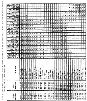
(2) The separation between co-channel stations that have been granted exclusivity and that are located at high sites in California north of 35° N Latitude and west of 118° W Longitude shall be determined as follows:
(i) Required co-channel separations between common antenna sites are given by table 1. A channel group assigned to a station on a site listed in the vertical column may not be re-assigned to a station on a site listed in the horizontal column if there is an “X” in the box created by the intersection of the vertical and horizontal lines. The geographic coordinates listed in the table represent an average for each particular site; all locations within 1.6 km (1 mi) of the coordinates will be considered to be at that site.
(ii) Required co-channel separations involving antenna sites not listed in table 1 shall be determined by Commission staff on a case by case basis. The interference potential of proposed assignments will be evaluated considering parameters such as antenna height, effective radiated power, terrain irregularities, and market conditions.
(3) Except as indicated in paragraph (b)(4) of this section, stations in Channel Blocks A through V that have been granted channel exclusivity and are located in the State of Washington at the locations listed in the table below shall be separated from co-channel stations by a minimum of 169 km (105 mi). Except as indicated in paragraph (b)(4) of this section, incumbent licensees in Channel Blocks F1 through V that have received the consent of all affected parties or a certified frequency coordinator to utilize an 18 dBµV/m signal strength interference contour, have been granted channel exclusivity and are located in the State of Washington at the locations listed in the table below shall be separated from co-channel stations by a minimum of 229 km (142 mi). Locations within one mile of the geographical coordinates listed in the table below will be considered to be at that site.
Note:Coordinates are referenced to North American Datum 1983 (NAD83).
| Site name | North latitude | West longitude |
|---|---|---|
| Mount Constitution | 48° 40′ 47.4″ | 122° 50′ 28.7″ |
| Lyman Mountain | 48° 35′ 41.4″ | 122° 09′ 39.6″ |
| Cultus Mountain | 48° 25′ 30.4″ | 122° 08′ 58.5″ |
| Gunsite Ridge | 48° 03′ 22.4″ | 121° 51′ 41.5″ |
| Gold Mountain | 47° 32′ 51.3″ | 122° 46′ 56.5″ |
| Buck Mountain | 47° 47′ 05.3″ | 122° 59′ 34.6″ |
| Cougar Mountain | 47° 32′ 39.4″ | 122° 06′ 34.4″ |
| Squak Mountain | 47° 30′ 14.4″ | 122° 03′ 34.4″ |
| Tiger Mountain | 47° 30′ 13.4″ | 121° 58′ 32.4″ |
| Devils Mountain | 48° 21′ 52.4″ | 122° 16′ 06.6″ |
| McDonald Mountain | 47° 20′ 11.3″ | 122° 51′ 30.5″ |
| Maynard Hill | 48° 00′ 58.3″ | 122° 55′ 35.6″ |
| North Mountain | 47° 19′ 07.3″ | 123° 20′ 48.6″ |
| Green Mountain | 47° 33′ 40.3″ | 122° 48′ 31.5″ |
| Capitol Peak | 46° 58′ 21.3″ | 123° 08′ 21.5″ |
| Rattlesnake Mountain | 47° 28′ 09.4″ | 121° 49′ 17.4″ |
| Three Sisters Mountain | 47° 07′ 19.4″ | 121° 53′ 34.4″ |
| Grass Mountain | 47° 12′ 14.1″ | 121° 47′ 42.4″ |
| Spar Pole Hill | 47° 02′ 51.4″ | 122° 08′ 39.4″ |
(4) Upon an applicant's specific request to the Commission or a frequency coordinator, co-channel stations may be separated by less than 113 km (70 mi) by meeting certain transmitter ERP and antenna height criteria. The following table indicates separations assignable to such co-channel stations for various transmitter power and antenna height combinations. The minimum separation permitted is 88 km (55 mi). Applicants will provide the Commission with a statement that the application is submitted for consideration under the table, a list of all co-channel stations within 113 km (70 mi), and the DHAATs and ERPs for these stations and the applicant's proposed station. Applicants seeking to be licensed for stations located at distances less than those prescribed in the table are required to secure a waiver and must submit with the application, in addition to the above, an interference analysis, based upon any of the generally-accepted terrain-based propagation models, that shows that co-channel stations would receive the same or greater interference protection than provided in the table. Requests for separations less than 88 km (55 mi) must also include an analysis of interference potential from mobile transmitters to existing co-channel base station receivers. Applicants seeking a waiver must submit with their application a certificate of service indicating that concurrent with the submission of the application to the Commission or a coordinator, all co-channel licensees within the applicable area were served with a copy of the application and all attachments thereto. Licensees thus served may file an opposition to the application within 30 days from the date the application is filed with the Commission.
(i) The directional height of the antenna above average terrain (DHAAT) is calculated from the average of the antenna heights above average terrain from 3 to 16 km (2 to 10 mi) from the proposed site along a radial extending in the direction of the existing station and the radials 15 degrees to either side of that radial.
(ii) Except for the sites listed in paragraphs (b)(1), (b)(2), and (b)(3) of this section, additional co-channel distance separation must be afforded to an existing station from an applicant wishing to locate a station less than 113 km (70 mi) from a co-channel station, where either the applicant's or the existing station is located at sites with DHAATs of 458 m (1500 ft) and above. The separation between short-spaced co-channel stations shall be determined as follows:
(A) Calculate the DHAAT in each direction between every existing co-channel station with 113 km (70 mi) and the proposed station.
(B) In the table, locate the approximate ERP and DHAAT values for the proposed and existing stations.
(C) When DHAAT values are greater than 458 m (1500 ft), use the required separation for 305 m (1000 ft) and add 1.6 km (1 mi) for every 30.5 km (100 ft), or increment thereof, of DHAAT above 458 m (1500 ft) to the distance indicated in the table. If both the proposed existing stations have DHAATs of 458 m (1500 ft) or more, the additional distance is separately determined for each station and the combined distance is added to the distance obtained from the table. Protection to existing stations will be afforded only up to 113 km (70 mi).
Short-Spacing Separation Table
| Proposed station ERP (watts)/DHAAT(m) 3 | Distance between stations (km) 1 2 | ||||||
|---|---|---|---|---|---|---|---|
| Existing station DHAAT (meters) 3 | |||||||
| 305 | 215 | 150 | 108 | 75 | 54 | 37 | |
| 1000/305 | 113 | 113 | 113 | 113 | 113 | 113 | 113 |
| 1000/215 | 113 | 113 | 113 | 113 | 113 | 113 | 110 |
| 1000/150 | 113 | 113 | 113 | 113 | 112 | 108 | 103 |
| 1000/108 | 113 | 113 | 113 | 110 | 107 | 103 | 98 |
| 1000/75 | 113 | 112 | 108 | 103 | 100 | 96 | 91 |
| 1000/54 | 113 | 109 | 105 | 100 | 97 | 93 | 88 |
| 1000/37 | 109 | 104 | 100 | 95 | 92 | 88 | 88 |
| 500/305 | 113 | 113 | 113 | 113 | 113 | 113 | 110 |
| 500/215 | 113 | 113 | 113 | 112 | 109 | 105 | 100 |
| 500/150 | 113 | 112 | 108 | 103 | 100 | 96 | 91 |
| 500/108 | 112 | 107 | 103 | 98 | 95 | 91 | 88 |
| 500/75 | 107 | 102 | 98 | 93 | 90 | 88 | 88 |
| 500/54 | 103 | 98 | 94 | 89 | 88 | 88 | 88 |
| 500/37 | 99 | 94 | 90 | 88 | 88 | 88 | 88 |
| 250/305 | 113 | 113 | 113 | 112 | 109 | 105 | 100 |
| 250/215 | 113 | 113 | 107 | 102 | 99 | 95 | 90 |
| 250/150 | 109 | 104 | 100 | 95 | 92 | 88 | 88 |
| 250/108 | 105 | 100 | 96 | 91 | 88 | 88 | 88 |
| 250/75 | 99 | 94 | 90 | 88 | 88 | 88 | 88 |
| 250/54 | 95 | 90 | 88 | 88 | 88 | 88 | 88 |
| 250/37 | 91 | 88 | 88 | 88 | 88 | 88 | 88 |
| 125/305 | 113 | 111 | 107 | 102 | 99 | 95 | 90 |
| 125/215 | 108 | 103 | 99 | 94 | 91 | 88 | 88 |
| 125/150 | 103 | 98 | 94 | 89 | 88 | 88 | 88 |
| 125/108 | 98 | 93 | 89 | 88 | 88 | 88 | 88 |
| 125/75 | 93 | 88 | 88 | 88 | 88 | 88 | 88 |
| 125/54 | 88 | 88 | 88 | 88 | 88 | 88 | 88 |
| 125/37 | 88 | 88 | 88 | 88 | 88 | 88 | 88 |
| 62/305 | 108 | 103 | 99 | 94 | 91 | 88 | 88 |
| 62/215 | 103 | 98 | 94 | 89 | 88 | 88 | 88 |
| 62/150 | 97 | 92 | 88 | 88 | 88 | 88 | 88 |
| 62/108 | 92 | 88 | 88 | 88 | 88 | 88 | 88 |
| 62/75 | 88 | 88 | 88 | 88 | 88 | 88 | 88 |
| 62/54 | 88 | 88 | 88 | 88 | 88 | 88 | 88 |
| 62/37 | 88 | 88 | 88 | 88 | 88 | 88 | 88 |
1 Separations for stations on Santiago Peak, Sierra Peak, Mount Lukens, and Mount Wilson (CA) and the locations in the State of Washington listed in paragraph (b)(3) of this section are 56 km (35 mi) greater than those listed in the table above. In the event of conflict between this table and the table of additional California high elevation sites shown in paragraph (b)(2) of this section, the latter will apply.
2 Distances shown are derived from the R-6602 curves and are based upon a non-overlap of the 22 dBu (F50,10) interference contour of the proposed station with the 40 dBu (F50,50) contour of the existing station(s). No consideration is given to the 40 dBu service contour of the proposed station and the 22 dBu contour of the existing station(s). The minimum separation of stations will be 88 km (55 mi).
3 All existing stations are assumed to operate with 1000 watts ERP. When the ERP and/or DHAAT of a proposed station or the DHAAT of an existing station is not indicated in the table, the next higher value(s) must be used.
(5) The separation between co-channel systems may be less than the separations defined above if an applicant submits with its application letters of concurrence indicating that the applicant and each co-channel licensee within the specified separation agree to accept any interference resulting from the reduced separation between their systems. Each letter from a co-channel licensee must certify that the system of the concurring licensee is constructed and fully operational. The applicant must also submit with its application a certificate of service indicating that all concurring co-channel licensees have been served with an actual copy of the application.
(6) A station located closer than the distances provided in this section to a co-channel station that was authorized as short-spaced under paragraph (b)(4) of this section shall be permitted to modify its facilities as long as the station does not extend its 22 dBu contour beyond its maximum 22 dBu contour (i.e., the 22 dBu contour calculated using the station's maximum power and antenna height at its original location) in the direction of the short-spaced station.
(7) Offset frequencies in the 811-821/856-866 MHz band for use only within U.S./Mexico border area, as designated in § 90.619(a), shall be considered co-channel with non-offset frequencies in this band as designated in § 90.613. New applications for frequencies in this band for stations adjacent to the U.S./Mexico border area must comply with the co-channel separation provisions of this section.
(c) Conventional systems authorized on frequencies in the Public Safety (except for those systems that have participated in a formal regional planning process as described in § 90.16) and Business/Industrial/Land Transportation categories which have not met the loading levels necessary for channel exclusivity will not be afforded co-channel protection.
(d) Geographic separation between fixed stations operating on adjacent channels in the 809-817/854-862 MHz Mid-Band segment must be based on lack of contour overlap as detailed in paragraphs (d)(1) through (4), unless the co-channel distance separation criteria in paragraph (b) of this section are met.
(1) Forward contour analysis. An applicant seeking to license a fixed station on a channel in the 809-817 MHz/854-862 MHz band segment will only be granted if the applicant's proposed interference contour creates no overlap with the 40 dBu F(50,50) contour of an incumbent operating a fixed station on an upper- or lower-adjacent channel. The applicant's interference contour is determined using the dBu level listed in the appropriate table in paragraph (d)(3) of this section. For this analysis the applicant shall plot the interference contour of its proposed fixed station at its proposed ERP but assume that any adjacent-channel incumbent licensee is operating at the maximum permitted ERP for the licensed antenna height.
(2) Reciprocal contour analysis. In addition to the contour analysis described in paragraph (d)(1) of this section, any applicant seeking to license a fixed station on a channel in the 809-817 MHz/854-862 MHz band segment must also pass a reciprocal contour analysis. Under the reciprocal analysis, the interference contour, F(50,10) of an incumbent operating a fixed station on an upper- or lower-adjacent channel must create no contour overlap with the proposed 40 dBu F(50,50) contour of the applicant's fixed station. The incumbent's interference contour is determined using the dBu level listed in the appropriate table in paragraph (d)(3) of this section. For this analysis the applicant shall plot the coverage contour of its fixed station, F(50,50), at its proposed ERP and antenna height above average terrain but plot the interference contour, F(50,10), of any adjacent-channel incumbent licensee at its maximum permitted ERP for the licensed antenna height.
(3) Contour matrix. Interference contour levels for the contour analysis described in paragraphs (d)(1) and (2) of this section are determined using Table 4 or Table 5 to this paragraph (d)(3). Table 4 is used to determine the interference contour F(50,10) level of a fixed station operating on a 12.5 kilohertz bandwidth channel while Table 5 is used to determine the interference contour F(50,10) level of a fixed station operating on a 25 kilohertz bandwidth channel. The dBu level of the interference contour is determined by cross-referencing the modulation type of the station operating on the 25 kilohertz bandwidth channel with the modulation type of the station operating on the 12.5 kilohertz bandwidth channel.


(4) Letters of concurrence. Applicants may submit applications which cause overlap under the forward contour analysis described in paragraph (d)(1) of this section provided the applicant includes a letter of concurrence from each incumbent that receives contour overlap. In the letter of concurrence, the incumbent operator must agree to accept any interference that occurs as a result of the contour overlap. Applicants may also submit applications which receive contour overlap under the reciprocal analysis described in paragraph (d)(2) of this section provided the applicant includes a letter of concurrence from each incumbent that causes contour overlap. In this case, the incumbent operator must state in its letter of concurrence that it does not object to the applicant receiving contour overlap from the incumbent's facility.
(e) Frequencies in the 809-817/854-862 MHz bands listed as available for eligibles in the Public Safety and Business/Industrial/Land Transportation Categories are available for inter-category sharing under the following conditions:
(1) Channels in the Public Safety and Business/Industrial/Land Transportation categories will be available to eligible applicants in those categories only if there are no frequencies in their own category and no public safety systems are authorized on those channels under consideration to be shared.
(2) Notwithstanding paragraph (e)(5) of this section, licensees of channels in the Business/Industrial/Land Transportation category may request a modification of the license, see § 1.947 of this chapter, to authorize use of the channels for commercial operation. The licensee may also, at the same time or thereafter, seek authorization to transfer or assign the license, see § 1.948 of this chapter, to any person eligible for licensing in the General or SMR categories. Applications submitted pursuant to this paragraph must be filed in accordance with the rules governing other applications for commercial channels, and will be processed in accordance with those rules. Grant of requests submitted pursuant to this paragraph is subject to the following conditions:
(i) A licensee that modifies its license to authorize commercial operations will not be authorized to obtain additional 800 MHz Business/Industrial/Land Transportation category channels for sites located within 113 km (70 mi.) of the station for which the license was modified, for a period of one year from the date the license is modified. This provision applies to the licensee, its controlling interests and their affiliates, as defined in § 1.2110 of this chapter.
(ii) With respect to licenses the initial application for which was filed on or after November 9, 2000, requests submitted pursuant to paragraph (e)(2) of this section may not be filed until five years after the date of the initial license grant. In the case of a license that is modified on or after November 9, 2000 to add 800 MHz Business/Industrial/Land Transportation frequencies or to add or relocate base stations that expand the licensee's interference contour, requests submitted pursuant to paragraph (e)(2) of this section for these frequencies or base stations may not be filed until five years after such modification.
(iii) Requests submitted pursuant to paragraph (e)(2) of this section must include a certification that written notice of the modification application has been provided to all Public Safety licensees, see § 90.20(a), with base stations within 113 km (70 mi.) of the site of the channel(s) for which authorization for commercial use is sought that operate within 25 kHz of the center of those channel(s). If, pursuant to paragraph (e)(2) of this section, modification and assignment or transfer applications are filed at different times, the written notice required by this paragraph must be provided each time.
(iv) The applicant must certify that it will take reasonable precautions to avoid causing harmful interference to Public Safety licensees, see § 90.20(a), and to take such action as may be necessary to eliminate interference to such licensees caused by its operations. (When an assignment or transfer application is filed pursuant to paragraph (e)(2) of this section, this representation is required only of the assignee or transferee.) Licensees of stations suffering or causing harmful interference are expected to cooperate and resolve this problem by mutually satisfactory arrangements. If the licensees are unable to do so, the Commission may impose restrictions including specifying the transmitter power, antenna height, or area or hours of operation.
(3) Licensees granted authorizations pursuant to paragraph (e)(2) of this section may at any time request modification of the license to authorize use of the channels consistent with the rules governing the category to which they are allocated, provided that the licensee meets the applicable eligibility requirements.
(4) [Reserved]
(5) The frequency coordinator must certify that frequencies are not available in the applicant's own category, and coordination is required from the applicable out-of-category coordinator.
(6) The out-of-category licensee must operate by the rules applicable to the category to which the frequency is allocated.
(f) Licensees of channels in the Business/Industrial/Land Transportation Categories in the 896-901/935-940 MHz bands may request a modification of the license, see § 1.947 of this chapter, to authorize use of the channels for commercial operation. The licensee may also, at the same time, or thereafter, seek authorization to transfer or assign the license, see § 1.948 of this chapter, to any person eligible for licensing in the General or SMR categories. Applications submitted pursuant to this paragraph must be filed in accordance with the rules governing other applications for commercial channels, and will be processed in accordance with those rules.
(g) Applications for Public Safety systems (both trunked and conventional) in the 806-809/851-854 MHz bands will be assigned and protected based on the criteria established in the appropriate regional plan. See § 90.16 and the Report and Order in General Docket 87-112.
(h) [Reserved]
[47 FR 41032, Sept. 16, 1982] Editorial Notes:1. For Federal Register citations affecting § 90.621, see the List of CFR Sections Affected, which appears in the Finding Aids section of the printed volume and at www.govinfo.gov.2. At 63 FR 68968, Dec. 14, 1998, § 90.621 was amended by adding a note before Table 1 and revising the first two columns of Table 1. However, Table 1 of § 90.621 as it appears in the October 1, 1998 revision of title 47 parts 80-end is an illustration and cannot be edited for amendments. For the convenience of the user, the revised text is set forth as follows:
§ 90.621 Selection and assignment of frequencies.(b) * * *
Table 1 - Co-Channel Separations Between Common Antenna Sites in the State of California North of 35° North Latitude and West of 118° West Longitude
[Note: Coordinates are referenced to North American Datum 1983 (NAD83)]
| North latitude | West longitude | * * * |
|---|---|---|
| 38°03′39.7″ | 122°36′20.9″ | * * * |
| 37°55′43.7″ | 122°35′14.9″ | * * * |
| 37°50′56.7″ | 122°29′59.9″ | * * * |
| 37°52′53.7″ | 121°55′08.9″ | * * * |
| 37°51′11.7″ | 122°12′33.9″ | * * * |
| 37°52′57.7″ | 122°13′14.9″ | * * * |
| 37°50′59.7″ | 122°11′33.9″ | * * * |
| 37°43′32.8″ | 122°24′55.9″ | * * * |
| 37°41′20.8″ | 122°26′11.9″ | * * * |
| 37°24′38.8″ | 122°18′23.9″ | * * * |
| 37°19′12.8″ | 122°08′36.9″ | * * * |
| 37°10′36.8″ | 121°54′27.8″ | * * * |
| 37°07′08.8″ | 121°50′01.8″ | * * * |
| 37°06′39.8″ | 121°50′32.8″ | * * * |
| 36°31′44.9″ | 121°36′27.8″ | * * * |
| 37°29′14.8″ | 121°52′06.8″ | * * * |
| 40°15′45.6″ | 122°05′41.0″ | * * * |
| 39°51′49.6″ | 121°41′23.9″ | * * * |
| 39°12′16.6″ | 121°49′05.9″ | * * * |
| 39°08′00.6″ | 121°06′01.8″ | * * * |
| 38°52′14.6″ | 121°07′42.8″ | * * * |
| 38°24′19.7″ | 122°06′33.9″ | * * * |
| 38°01′14.7″ | 120°35′09.7″ | * * * |
| 37°30′30.8″ | 121°22′29.8″ | * * * |
| 37°32′31.8″ | 120°03′48.6″ | * * * |
| 37°04′09.8″ | 119°25′42.5″ | * * * |
| 36°44′37.8″ | 119°17′02.4″ | * * * |
| 36°18′09.8″ | 120°24′06.6″ | * * * |
| 36°17′06.8″ | 118°50′22.3″ | * * * |
| 35°38′28.8″ | 118°47′11.3″ | * * * |
| 35°33′08.8″ | 118°49′23.3″ | * * * |
| 35°17′16.9″ | 119°30′58.4″ | * * * |
| 35°17′26.9″ | 119°45′51.5″ | * * * |
| 35°16′50.9″ | 119°44′55.5″ | * * * |