Title 33
PART 401 APPENDIX
| From - | To - | Maximum speed over the bottom, knots | |
|---|---|---|---|
| Col. III | Col. IV | ||
| 1. Upper Entrance South Shore Canal Buoy 1 | Lake St. Louis, Buoy A13 | 10.5 | 10.5 |
| 2. Lake St. Louis Buoy A13 | Lower Entrance Lower Beauharnois Lock | 12 (dnb); 14 (upb) | 11 (upb); 13 (dnb). |
| 3. Upper Entrance, Upper Beauharnois Lock | Lake St. Francis, Buoy D3 | 9 upb; 10.5 dnb | 9 upb; 10.5 dnb. |
| 4. Lake St. Francis, Buoy D3 | Lake St. Francis, Buoy D49 | 12 | 12. |
| 5. Lake St. Francis, Buoy D49 | Snell Lock | 8.5 upb; 10.5 dnb | 8 upb; 10.5 dnb. |
| 6. Eisenhower Lock | Iroquois Lock | 11.5 | 10.5. |
| 7. Iroquois Lock | McNair Island, Lt. 137 | 13 | 10.5. |
| 8. McNair Island, Lt. 137 | Deer Island, Lt. 186 | 11.5 | 10.5. |
| 9. Deer Island, Lt. 186 | Bartlett Point, Lt. 227 | 8.5 upb; 10.5 dnb | 8 upb; 10.5 dnb. |
| 10. Bartlett Point, Lt. 227 | Tibbetts Point Traffic Lighted Buoy Mo (A) | 13 | 10.5 |
| 11. Junction of Canadian Middle Channel and Main Channel abreast of Ironsides Island | Open Waters between Wolfe and Howe Islands through the said Middle Channel | 9.5 | 9.5. |
| 12. Port Robinson | Ramey's Bend through the Welland Bypass | 8 | 8. |
| 13. All other canals | 6 | 6. | |
1 Maximum speeds at which a vessel may travel in the identified area in both normal and high water conditions are set out in this schedule. The Manager and the Corporation will, from time to time, designate the set of speed limits that is in effect.
Schedule III to Subpart A of Part 401 - Calling-in Table
33:3.0.2.1.2.1.22.99.26 :
Schedule III to Subpart A of Part 401 - Calling-in Table| C.I.P. and checkpoint | Station to call | Message content |
|---|---|---|
| upbound vessels | ||
| 1. C.I.P. 2 - entering Sector 1 (order of passing through established): | ||
| (a) Vessels transiting from the Lower St. Lawrence River | Seaway Beauharnois, channel 14 | 1. Name of vessel. 2. Location. 3. Destination. 4. Drafts, fore and aft. 5. Cargo. 6. Manifested dangerous cargo - nature and quantity; IMO classification; location where dangerous cargo is stowed. 7. Pilot requirement - Lake Ontario. 8. Confirm pilot requirement - Upper Beauharnois Lock (inland vessels only). |
| (b) Vessels in Montreal Harbor, dock, berth or anchorage: | ||
| (i) Before getting under way | ......do | 1. Name of vessel. 2. Location. 3. Destination. 4. Drafts, fore and aft. 5. Cargo. 6. Manifested dangerous cargo - nature and quantity; IMO classification; location where dangerous cargo is stowed. 7. Pilot requirement - Lake Ontario. 8. Confirm pilot requirement - Upper Beauharnois Lock (inland vessels only). |
| (ii) C.I.P. 2 - entering Sector 1 (order of passing through established) | ......do | 1. Name of vessel. 2. Location. |
| 2. C.I.P. 3 - order of passing through established | ......do | 1. Name of vessel. 2. Location. |
| 3. Exiting Upper Beauharnois Lock | ......do | 1. Name of vessel. 2. Location. 3. ETA C.I.P. 7. 4. Confirm pilot requirement - Snell Lock (inland vessels only). |
| 4. C.I.P. 7 - leaving sector 1 | ......do | 1. Name of vessel 2. Location. |
| 5. C.I.P. 7 - entering sector 2 | Seaway Eisenhower, channel 12 | 1. Name of vessel. 2. Location. 3. ETA Snell lock. |
| 6. C.I.P. 8 - order of passing through established | ......do | 1. Name of vessel. 2. Location. |
| 7. C.I.P. 8A | ......do | 1. Name of vessel. 2. Location. |
| 8. Exiting Eisenhower Lock | ......do | 1. Name of vessel. 2. Location. 3. ETA C.I.P. 11. 4. Confirm pilot requirement - Lake Ontario. 5. All ports of call. |
| 9. C.I.P. 11 - leaving sector 2 | ......do | 1. Name of vessel. 2. Location. |
| 10. C.I.P. 11 - entering sector 3 | Seaway Iroquois, channel 11 | 1. Name of vessel. 2. Location. |
| 11. C.I.P. 12 - order of passing through established | ......do | 1. Name of vessel. 2. Location. |
| 12. Exiting Iroquois lock | ......do | 1. Name of vessel. 2. Location. 3. ETA Cross Over Island. |
| 13. Cross Over Island - leaving sector 3 | ......do | 1. Name of vessel. 2. Location. |
| 14. Cross Over Island - entering sector 4 | Seaway Clayton, channel 13 | 1. Name of vessel. 2. Location. 3. ETA Cape Vincent or River Port. |
| 15. Whale back Shoal - Con | ......do | 4. Confirm pilot requirement - Lake Ontario. |
| 16. Wolfe Island Cut (Beauvais Point) - vessels leaving main channel | ......do | 1. Name of vessel. 2. Location. 3. ETA Kingston. |
| 17. Cape Vincent | ......do | 1. Name of vessel. 2. Location. 3. ETA Sodus Point. 4. ETA Port Weller (C.I.P. 15) or Lake Ontario Port. 5. Pilot requirement - Port Weller. |
| 18. Sodus Point | Seaway Sodus, Channel 12 | 1. Name of vessel. 2. Location. 3. ETA mid-Lake Ontario. |
| 19. Mid Lake Ontario - entering Sector 5 | Seaway Newcastle, channel 11 | 1. Name of Vessel. 2. Location. 3. Pilot requirement - Lake Erie. |
| 20. Mid-Lake Ontario - entering sector 5 | ......do | 1. Name of vessel. 2. Location. |
| 21. Newcastle | ......do | 1. Name of Vessel. 2. Location. |
| 22. C.I.P. 15 - order of passing through established | Seaway Welland, channel 14 | 1. Name of vessel. 2. Location. 3. Destination. 4. Drafts, fore and aft. 5. Cargo. 6. Pilot requirement - Lake Erie. |
| Port Colborne piers | ......do | 1. Name of vessel. 2. Location. 3. ETA Long Point. |
| 23. C.I.P. 16 | Seaway Long Point, channel 11 | 1. Name of vessel. 2. Location. |
| 24. Long Point - leaving sector 7 | ......do | 1. Name of vessel. 2. Location. |
| downbound vessels | ||
| 29. Long Point - entering Sector 7 | Seaway Long Point, channel 11 | 1. Name of Vessel. 2. Location. 3. ETA C.I.P. 16 or Port. 4. Manifested dangerous cargo, including: - nature and quantity. - IMO classification. - location where dangerous cargo is stowed. and, if proceeding to Welland Canal, 5. Destination. 6. Drafts, fore and aft. 7. Cargo. 8. Pilot requirement - Lake Ontario. |
| 30. C.I.P. 16 - order of passing through established | Seaway Welland, channel 14 | 1. Name of Vessel. 2. Location. |
| 31. Exiting lock No. 1, Welland Canal | ......do | 1. Name of vessel 2. Location. 3. ETA Newcastle. 4. ETA Cape Vincent or Lake Ontario Port. 5. Pilot requirement - Cape Vincent. |
| 32. C.I.P. 15 | Seaway Newcastle, channel 11 | 1. Name of vessel. 2. Location. |
| 33. Newcastle | ......do | 1. Name of vessel. 2. Location. 3. ETA mid-Lake Ontario. 4. ETA Sodus Point. |
| 34. Mid-Lake Ontario - leaving sector 5 | ......do | 1. Name of vessel. 2. Location. |
| 35. Mid-Lake Ontario - entering Sector 4 | Seaway Sodus, Channel 12 | 1. Name of vessel. 2. Location. |
| 36. Sodus Point | Seaway Sodus, Channel 12 | 1. Name of vessel. 2. Location. 3. Updated ETA Cape Vincent or Lake Ontario Port. 4. Confirm river pilot requirement. 5. Pilot requirement - Snell Lock and/or Upper Beauharnois Lock (inland vessels only). |
| 37. Cape Vincent | Seaway Clayton, channel 13 | 1. Name of vessel 2. Location. 3. ETA Cross Over Island or river port. |
| 38. Wolfe Island Cut (Quebec Head) - vessels entering main channel | ......do | 1. Name of vessel. 2. Location. 3. ETA Cross Over Island or river port. |
| 39. Cross Over Island - leaving sector 4 | ......do | 1. Name of vessel. 2. Location. |
| 40. Cross Over Island - entering sector 3 | Seaway Iroquois, channel 11 | 1. Name of vessel. 2. Location. |
| 41. C.I.P. 14 | ......do | 1. Name of vessel. 2. Location. |
| 42. C.I.P. 13 - order of passing through established | ......do | 1. Name of vessel. 2. Location. |
| 43. Exiting Iroquois Lock | ......do | 1. Name of vessel. 2. Location. 3. ETA C.I.P. 10. 4. Harbor or river pilot requirement - St. Lambert. 5. Confirm pilot requirement - Snell Lock (inland vessels only). |
| 44. C.I.P. 10 - leaving sector 3 | ......do | 1. Name of vessel. 2. Location. |
| 45. C.I.P. 10 - entering sector 2 | Seaway Eisenhower, channel 12 | 1. Name of vessel. 2. Location. |
| 46. C.I.P. 9 - order of passing through established | ......do | 1. Name of vessel. 2. Location. 3. ETA Snell lock. |
| 47. Exiting Snell lock | ......do | 1. Name of vessel. 2. Location. 3. ETA C.I.P. 6. |
| 48. Buoy D47 Lake St. Francis | ......do | 1. Name of vessel. 2. Location. 3. Confirm pilot requirement - Upper Beauharnois Lock (inland vessels only). |
| 49. C.I.P. 6 - leaving sector 2 | ......do | 1. Name of Vessel. 2. Location. |
| 50. C.I.P. 6 - entering sector 1 | Seaway Beauharnois, channel 14 | 1. Name of vessel. 2. Location. |
| 51. C.I.P. 5 - order of passing through established | ......do | 1. Name of vessel. 2. Location. |
| 52. Exiting Lower Beauharnois Lock | ......do | 1. Name of vessel. 2. Location. 3. Confirm harbor or river pilot requirement - St. Lambert. 4. Montreal Harbor Berth number (if applicable). |
| 53. St. Nicholas Island | ......do | 1. Name of vessel. 2. Location. |
| 54. St. Lambert lock to C.I.P. 2 - leaving sector 1 | ......do | 1. Name of vessel. 2. Location. |
| Upbound and Downbound Vessels | ||
| 55. Vessels departing from ports between mid-lake Ontario and Long Point, except vessels westbound from a Lake Erie port and not transiting the Welland Canal | Appropriate Seaway station for sector | 1. Name of Vessel. 2. Location. 3. Manifested dangerous cargo: - nature and quantity - IMO classification - location where dangerous cargo is stowed. and if proceeding to Welland Canal, 4. Destination. 5. Drafts, fore and aft. 6. Cargo. 7. Pilot requirement: - Lake Erie if upbound or Lake Ontario if downbound. |
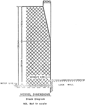
Appendix I to Subpart A of Part 401 - Vessel Dimensions
33:3.0.2.1.2.1.22.99.27 : Appendix I
Appendix I to Subpart A of Part 401 - Vessel DimensionsStructures are located at a number of Seaway locks which, when fully raised, overhang the lock wall at a given point, thereby limiting:
(a) The height of a vessel above the water line measured at the vessel's side; and
(b) The height of other structures that are located near the sides of the vessel, such as derricks, crosstrees, antennas, etc.
The following block diagram shows the limits beyond which a vessel's hull or superstructure cannot extend when the vessel is alongside the lock wall.
The limits in the block diagram are based on vessels with a maximum allowable beam of 23.2 m. For vessels that have a beam width less than this and that have dimensions exceeding the limits of the block diagram (measured with the vessel alongside the lock wall), a special permission to transit must be obtained. (Accurate measurements may be required before such permission is granted).
Caution: Masters must take into account the ballast draft of the vessel when verifying the maximum permissible dimensions. Bridge wings, antennas, masts and, in some cases, the samson posts or store cranes could be outside the limits of the block diagram and could override the lock wall. Masters and pilots must take this into consideration and exercise extreme caution when entering or exiting locks to ensure that the vessel does not contact any of the structures on the lock.
 (68 Stat.
93-96, 33 U.S.C. 981-990, as amended and secs. 4, 5, 6, 7, 8, 12
and 13 of sec. 2 of Pub. L. 95-474, 92 Stat. 1471) [45 FR 52381,
Aug. 7, 1980, as amended at 49 FR 30936, Aug. 2, 1984; 61 FR 19552,
May 2, 1996; 81 FR 13747, Mar. 15, 2016]
(68 Stat.
93-96, 33 U.S.C. 981-990, as amended and secs. 4, 5, 6, 7, 8, 12
and 13 of sec. 2 of Pub. L. 95-474, 92 Stat. 1471) [45 FR 52381,
Aug. 7, 1980, as amended at 49 FR 30936, Aug. 2, 1984; 61 FR 19552,
May 2, 1996; 81 FR 13747, Mar. 15, 2016]