Title 43
SECTION 2094.1
2094.1 Methods of measuring; restrictions.
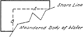
§ 2094.1 Methods of measuring; restrictions.(a) In the consideration of applications to enter lands shown upon plats of public surveys in Alaska, as abutting upon navigable waters, the restriction as to length of claims shall be determined as follows: The length of the water front of a subdivision will be considered as represented by the longest straight-line distance between the shore corners of the tract, measured along lines parallel to the boundaries of the subdivision; and the sum of the distances of each subdivision of the application abutting on the water, so determined, shall be considered as the total shore length of the application. Where, so measured, the excess of shore length is greater than the deficiency would be if an end tract or tracts were eliminated, such tract or tracts shall be excluded, otherwise the application may be allowed if in other respects proper.
(b) The same method of measuring shore space will be used in the case of special surveys, where legal subdivisions of the public lands are not involved.
(c) The following sketch shows the method of measuring the length of shore space, the length of line A or line B, whichever is the longer, representing the length of shore space which is chargeable to the tract: