Title 47
SECTION 80.769
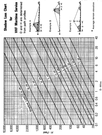
80.769 Shadow loss.
§ 80.769 Shadow loss.Where the transmission path is obstructed the received signal must be adjusted to include shadow loss. Attenuation due to shadowing must be taken from § 80.769 Graph 1, as follows:
(a) Inspect the map(s) to determine if a hill(s) obstructs an imaginary line of sight (dashed line on illustrative profiles of § 80.769 Graph 1 from the average terrain elevation at the coast station antenna to the water level at the ship location. If average terrain elevation exceeds the actual ground elevation at the antenna site, the latter elevation must be used as the average terrain elevation.
(b) If a hill appears to obstruct the radio path, plot the antenna site elevation, the obstruction elevation and the height of the ship station on rectangular coordinate paper using elevation above mean sea level as the vertical scale and distance in statute miles as the horizontal scale. Then draw a straight line between the antenna and the ship.
(c) If a hill obstructs the imaginary line of sight, determine its height (H) above the imaginary line and its distance (D) from either the coast or ship station, whichever is nearer, as illustrated by examples “A” and “B” on Graph 1.
(d) Read the shadow loss from this Graph 1 and subtract that loss from the computed received signal.
(e) Where more than one hill obstructs the transmission path, determine the height and position of a single equivalent hill, as illustrated by example “C” on this graph. Read the shadow loss from this graph for the equivalent hill.