Title 40
SECTION 52.128
52.128 Rule for unpaved parking lots, unpaved roads and vacant lots.
§ 52.128 Rule for unpaved parking lots, unpaved roads and vacant lots.(a) General - (1) Purpose. The purpose of this section is to limit the emissions of particulate matter into the ambient air from human activity on unpaved parking lots, unpaved roads and vacant lots.
(2) Applicability. The provisions of this section shall apply to owners/operators of unpaved roads, unpaved parking lots and vacant lots and responsible parties for weed abatement on vacant lots in the Phoenix PM-10 nonattainment area. This section does not apply to unpaved roads, unpaved parking lots or vacant lots located on an industrial facility, construction, or earth-moving site that has an approved permit issued by Maricopa County Environmental Services Division under Rule 200, Section 305, Rule 210 or Rule 220 containing a Dust Control Plan approved under Rule 310 covering all unpaved parking lots, unpaved roads and vacant lots. This section does not apply to the two Indian Reservations (the Salt River Pima-Maricopa Indian Community and the Fort McDowell Mojave-Apache Indian Community) and a portion of a third reservation (the Gila River Indian Community) in the Phoenix PM-10 nonattainment area. Nothing in this definition shall preclude applicability of this section to vacant lots with disturbed surface areas due to construction, earth-moving, weed abatement or other dust generating operations which have been terminated for over eight months.
(3) The test methods described in Appendix A of this section shall be used when testing is necessary to determine whether a surface has been stabilized as defined in paragraph (b)(16) of this section.
(b) Definitions - (1) Average daily trips (ADT). The average number of vehicles that cross a given surface during a specified 24-hour time period as determined by the Institute of Transportation Engineers Trip Generation Report (6th edition, 1997) or tube counts.
(2) Chemical/organic stabilizer - Any non-toxic chemical or organic dust suppressant other than water which meets any specifications, criteria, or tests required by any federal, state, or local water agency and is not prohibited for use by any applicable law, rule or regulation.
(3) Disturbed surface area - Any portion of the earth's surface, or materials placed thereon, which has been physically moved, uncovered, destabilized, or otherwise modified from its undisturbed natural condition, thereby increasing the potential for emission of fugitive dust.
(4) Dust suppressants - Water, hygroscopic materials, solution of water and chemical surfactant, foam, or non-toxic chemical/organic stabilizers not prohibited for use by any applicable law, rule or regulation, as a treatment material to reduce fugitive dust emissions.
(5) EPA - United States Environmental Protection Agency, Region IX, 75 Hawthorne Street, San Francisco, California 94105.
(6) Fugitive dust - The particulate matter entrained in the ambient air which is caused from man-made and natural activities such as, but not limited to, movement of soil, vehicles, equipment, blasting, and wind. This excludes particulate matter emitted directly from the exhaust of motor vehicles and other internal combustion engines, from portable brazing, soldering, or welding equipment, and from piledrivers.
(7) Lot - A parcel of land identified on a final or parcel map recorded in the office of the Maricopa County recorder with a separate and distinct number or letter.
(8) Low use unpaved parking lot - A lot on which vehicles are parked no more than thirty-five (35) days a year, excluding days where the exemption in paragraph (c)(2) of this section applies.
(9) Motor vehicle - A self-propelled vehicle for use on the public roads and highways of the State of Arizona and required to be registered under the Arizona State Uniform Motor Vehicle Act, including any non-motorized attachments, such as, but not limited to, trailers or other conveyances which are connected to or propelled by the actual motorized portion of the vehicle.
(10) Off-road motor vehicle - any wheeled vehicle which is used off paved roadways and includes but is not limited to the following:
(i) Any motor cycle or motor-driven cycle;
(ii) Any motor vehicle commonly referred to as a sand buggy, dune buggy, or all terrain vehicle.
(11) Owner/operator - any person who owns, leases, operates, controls, maintains or supervises a fugitive dust source subject to the requirements of this section.
(12) Paving - Applying asphalt, recycled asphalt, concrete, or asphaltic concrete to a roadway surface.
(13) Phoenix PM-10 nonattainment area - such area as defined in 40 CFR 81.303, excluding Apache Junction.
(14) PM-10 - Particulate matter with an aerodynamic diameter less than or equal to a nominal 10 micrometers as measured by reference or equivalent methods that meet the requirements specified for PM-10 in 40 CFR part 50, Appendix J.
(15) Reasonably available control measures (RACM) - Techniques used to prevent the emission and/or airborne transport of fugitive dust and dirt.
(16) Stabilized surface - (i) Any unpaved road or unpaved parking lot surface where:
(A) Any fugitive dust plume emanating from vehicular movement does not exceed 20 percent opacity as determined in section I.A of Appendix A of this section; and
(B) Silt loading (weight of silt per unit area) is less than 0.33 ounces per square foot as determined by the test method in section I.B of Appendix A of this section OR where silt loading is greater than or equal to 0.33 ounces per square foot and silt content does not exceed six (6) percent for unpaved road surfaces or eight (8) percent for unpaved parking lot surfaces as determined by the test method in section I.B of Appendix A of this section.
(ii) Any vacant lot surface with:
(A) A visible crust which is sufficient as determined in section II.1 of Appendix A of this section;
(B) A threshold friction velocity (TFV), corrected for non-erodible elements, of 100 cm/second or higher as determined in section II.2 of Appendix A of this section;
(C) Flat vegetation cover equal to at least 50 percent as determined in section II.3 of Appendix A of this section;
(D) Standing vegetation cover equal to or greater than 30 percent as determined in section II.4 of Appendix A of this section; or
(E) Standing vegetation cover equal to or greater than 10 percent as determined in section II.4 of Appendix A of this section where threshold friction velocity, corrected for non-erodible elements, as determined in section II.2 of Appendix A of this section is equal to or greater than 43 cm/second.
(17) Unpaved parking lot - A privately or publicly owned or operated area utilized for parking vehicles that is not paved and is not a Low use unpaved parking lot.
(18) Unpaved road - Any road, equipment path or driveway used by motor vehicles or off-road motor vehicles that is not paved which is open to public access and owned/operated by any federal, state, county, municipal or other governmental or quasi-governmental agencies.
(19) Urban or suburban open area - An unsubdivided or undeveloped tract of land adjoining a residential, industrial or commercial area, located on public or private property.
(20) Vacant lot - A subdivided residential, industrial, institutional, governmental or commercial lot which contains no approved or permitted buildings or structures of a temporary or permanent nature.
(c) Exemptions. The following requirements in paragraph (d) of this section do not apply:
(1) In paragraphs (d)(1), (d)(2) and (d)(4)(iii) of this section: Any unpaved parking lot or vacant lot 5,000 square feet or less.
(2) In paragraphs (d)(1) and (d)(2) of this section: Any unpaved parking lot on any day in which ten (10) or fewer vehicles enter.
(3) In paragraphs (d)(4)(i) and (d)(4)(ii) of this section: Any vacant lot with less than 0.50 acre (21,780 square feet) of disturbed surface area(s).
(4) In paragraph (d) of this section: Non-routine or emergency maintenance of flood control channels and water retention basins.
(5) In paragraph (d) of this section: Vehicle test and development facilities and operations when dust is required to test and validate design integrity, product quality and/or commercial acceptance. Such facilities and operations shall be exempted from the provisions of this section only if such testing is not feasible within enclosed facilities.
(6) In paragraph (d)(4)(i) of this section: Weed abatement operations performed on any vacant lot or property under the order of a governing agency for the control of a potential fire hazard or otherwise unhealthy condition provided that mowing, cutting, or another similar process is used to maintain weed stubble at least three (3) inches above the soil surface. This includes the application of herbicides provided that the clean-up of any debris does not disturb the soil surface.
(7) In paragraph (d)(4)(i) of this section: Weed abatement operations that receive an approved Earth Moving permit under Maricopa County Rule 200, Section 305 (adopted 11/15/93).
(d) Requirements - (1) Unpaved parking lots. Any owners/operators of an unpaved parking lot shall implement one of the following RACM on any surface area(s) of the lot on which vehicles enter and park.
(i) Pave; or
(ii) Apply chemical/organic stabilizers in sufficient concentration and frequency to maintain a stabilized surface; or
(iii) Apply and maintain surface gravel uniformly such that the surface is stabilized; or
(iv) Apply and maintain an alternative control measure such that the surface is stabilized, provided that the alternative measure is not prohibited under paragraph (b)(2) or (b)(4) of this section.
(2) Any owners/operators of a low use unpaved parking lot as defined in paragraph (b)(8) of this section shall implement one of the RACM under paragraph (d)(1) of this section on any day(s) in which over 100 vehicles enter the lot, such that the surface area(s) on which vehicles enter and park is/are stabilized throughout the duration of time that vehicles are parked.
(3) Unpaved roads. Any owners/operators of existing unpaved roads with ADT volumes of 250 vehicles or greater shall implement one of the following RACM along the entire surface of the road or road segment that is located within the Phoenix non-attainment area by June 10, 2000:
(i) Pave; or
(ii) Apply chemical/organic stabilizers in sufficient concentration and frequency to maintain a stabilized surface; or
(iii) Apply and maintain surface gravel uniformly such that the surface is stabilized; or
(iv) Apply and maintain an alternative control measure such that the surface is stabilized, provided that the alternative measure is not prohibited under paragraph (b)(2) or (b)(4) of this section.
(4) Vacant lots. The following provisions shall be implemented as applicable.
(i) Weed abatement. No person shall remove vegetation from any vacant lot by blading, disking, plowing under or any other means without implementing all of the following RACM to prevent or minimize fugitive dust.
(A) Apply a dust suppressant(s) to the total surface area subject to disturbance immediately prior to or during the weed abatement.
(B) Prevent or eliminate material track-out onto paved surfaces and access points adjoining paved surfaces.
(C) Apply a dust suppressant(s), gravel, compaction or alternative control measure immediately following weed abatement to the entire disturbed surface area such that the surface is stabilized.
(ii) Disturbed surfaces. Any owners/operators of an urban or suburban open area or vacant lot of which any portion has a disturbed surface area(s) that remain(s) unoccupied, unused, vacant or undeveloped for more than fifteen (15) calendar days shall implement one of the following RACM within sixty (60) calendar days following the disturbance.
(A) Establish ground cover vegetation on all disturbed surface areas in sufficient quantity to maintain a stabilized surface; or
(B) Apply a dust suppressant(s) to all disturbed surface areas in sufficient quantity and frequency to maintain a stabilized surface; or
(C) Restore to a natural state, i.e. as existing in or produced by nature without cultivation or artificial influence, such that all disturbed surface areas are stabilized; or
(D) Apply and maintain surface gravel uniformly such that all disturbed surface areas are stabilized; or
(E) Apply and maintain an alternative control measure such that the surface is stabilized, provided that the alternative measure is not prohibited under paragraph (b)(2) or (b)(4) of this section.
(iii) Motor vehicle disturbances. Any owners/operators of an urban or suburban open area or vacant lot of which any portion has a disturbed surface area due to motor vehicle or off-road motor vehicle use or parking, notwithstanding weed abatement operations or use or parking by the owner(s), shall implement one of the following RACM within 60 calendar days following the initial determination of disturbance.
(A) Prevent motor vehicle and off-road motor vehicle trespass/ parking by applying fencing, shrubs, trees, barriers or other effective measures; or
(B) Apply and maintain surface gravel or chemical/organic stabilizer uniformly such that all disturbed surface areas are stabilized.
(5) Implementation date of RACM. All of the requirements in paragraph (d) of this section shall be effective eight (8) months from September 2, 1998. For requirements in paragraph (d)(4)(ii) and (d)(4)(iii) of this section, RACM shall be implemented within eight (8) months from September 2, 1998, or within 60 calendar days following the disturbance, whichever is later.
(e) Monitoring and records. (1) Any owners/operators that are subject to the provisions of this section shall compile and retain records that provide evidence of control measure application, indicating the type of treatment or measure, extent of coverage and date applied. For control measures involving chemical/organic stabilization, records shall also indicate the type of product applied, vendor name, label instructions for approved usage, and the method, frequency, concentration and quantity of application.
(2) Copies of control measure records and dust control plans along with supporting documentation shall be retained for at least three years.
(3) Agency surveys. (i) EPA or other appropriate entity shall conduct a survey of the number and size (or length) of unpaved roads, unpaved parking lots, and vacant lots subject to the provisions of this section located within the Phoenix PM-10 nonattainment area beginning no later than 365 days from September 2, 1998.
(ii) EPA or other appropriate entity shall conduct a survey at least every three years within the Phoenix PM-10 nonattainment area beginning no later than 365 days from September 2, 1998, which includes:
(A) An estimate of the percentage of unpaved roads, unpaved parking lots, and vacant lots subject to this section to which RACM as required in this section have been applied; and
(B) A description of the most frequently applied RACM and estimates of their control effectiveness.
Appendix A to § 52.128 - Test Methods To Determine Whether A Surface Is Stabilized I. Unpaved Roads and Unpaved Parking Lots A. Opacity ObservationsConduct opacity observations in accordance with Reference Method 9 (40 CFR Part 60, appendix A) and Methods 203A and 203C of this appendix, with opacity readings taken at five second observation intervals and two consecutive readings per plume beginning with the first reading at zero seconds, in accordance with Method 203C, sections 2.3.2. and 2.4.2 of this appendix. Conduct visible opacity tests only on dry unpaved surfaces (i.e. when the surface is not damp to the touch) and on days when average wind speeds do not exceed 15 miles per hour (mph).
(i) Method 203A - Visual Determination of Opacity of Emissions From Stationary Sources for Time-Arranged RegulationsMethod 203A is virtually identical to EPA's Method 9 (40 CFR Part 60 Appendix A) except for the data-reduction procedures, which provide for averaging times other than 6 minutes. That is, using Method 203A with a 6-minute averaging time would be the same as following EPA Method 9 (40 CFR Part 60, Appendix A). Additionally, Method 203A provides procedures for fugitive dust applications. The certification procedures provided in section 3 are virtually identical to Method 9 (40 CFR Part 60, Appendix A) and are provided here, in full, for clarity and convenience.
1. Applicability and Principle1.1 Applicability. This method is applicable for the determination of the opacity of emissions from sources of visible emissions for time-averaged regulations. A time-averaged regulation is any regulation that requires averaging visible emission data to determine the opacity of visible emissions over a specific time period.
1.2 Principle. The opacity of emissions from sources of visible emissions is determined visually by an observer qualified according to the procedures of section 3.
2. ProceduresAn observer qualified in accordance with section 3 of this method shall use the following procedures for visually determining the opacity of emissions.
2.1 Procedures for Emissions from Stationary Sources. These procedures are not applicable to this section.
2.2 Procedures for Fugitive Process Dust Emissions. These procedures are applicable for the determination of the opacity of fugitive emissions by a qualified observer. The qualified field observer should do the following:
2.2.1 Position. Stand at a position at least 5 meters from the fugitive dust source in order to provide a clear view of the emissions with the sun oriented in the 140-degree sector to the back. Consistent as much as possible with maintaining the above requirements, make opacity observations from a position such that the line of vision is approximately perpendicular to the plume and wind direction. As much as possible, if multiple plumes are involved, do not include more than one plume in the line of sight at one time.
2.2.2 Field Records. Record the name of the plant or site, fugitive source location, source type [pile, stack industrial process unit, incinerator, open burning operation activity, material handling (transfer, loading, sorting, etc.)], method of control used, if any, observer's name, certification data and affiliation, and a sketch of the observer's position relative to the fugitive source. Also, record the time, estimated distance to the fugitive source location, approximate wind direction, estimated wind speed, description of the sky condition (presence and color of clouds), observer's position relative to the fugitive source, and color of the plume and type of background on the visible emission observation form when opacity readings are initiated and completed.
2.2.3 Observations. Make opacity observations, to the extent possible, using a contrasting background that is perpendicular to the line of vision. For roads, storage piles, and parking lots, make opacity observations approximately 1 meter above the surface from which the plume is generated. For other fugitive sources, make opacity observations at the point of greatest opacity in that portion of the plume where condensed water vapor is not present. For intermittent sources, the initial observation should begin immediately after a plume has been created above the surface involved. Do not look continuously at the plume but, instead, observe the plume momentarily at 15-second intervals.
2.3 Recording Observations. Record the opacity observations to the nearest 5 percent every 15 seconds on an observational record sheet. Each momentary observation recorded represents the average opacity of emissions for a 15-second period.
2.4 Data Reduction for Time-Averaged Regulations. A set of observations is composed of an appropriate number of consecutive observations determined by the averaging time specified. Divide the recorded observations into sets of appropriate time lengths for the specified averaging time. Sets must consist of consecutive observations; however, observations immediately preceding and following interrupted observations shall be deemed consecutive. Sets need not be consecutive in time and in no case shall two sets overlap, resulting in multiple violations. For each set of observations, calculate the appropriate average opacity.
3. Qualification and Testing3.1 Certification Requirements. To receive certification as a qualified observer, a candidate must be tested and demonstrate the ability to assign opacity readings in 5 percent increments to 25 different black plumes and 25 different white plumes, with an error not to exceed 15 percent opacity on any one reading and an average error not to exceed 7.5 percent opacity in each category. Candidates shall be tested according to the procedures described in paragraph 3.2. Any smoke generator used pursuant to paragraph 3.2 shall be equipped with a smoke meter which meets the requirements of paragraph 3.3. Certification tests that do not meet the requirements of paragraphs 3.2 and 3.3 are not valid.
The certification shall be valid for a period of 6 months, and after each 6-month period, the qualification procedures must be repeated by an observer in order to retain certification.
3.2 Certification Procedure. The certification test consists of showing the candidate a complete run of 50 plumes, 25 black plumes and 25 white plumes, generated by a smoke generator. Plumes shall be presented in random order within each set of 25 black and 25 white plumes. The candidate assigns an opacity value to each plume and records the observation on a suitable form. At the completion of each run of 50 readings, the score of the candidate is determined. If a candidate fails to qualify, the complete run of 50 readings must be repeated in any retest. The smoke test may be administered as part of a smoke school or training program, and may be preceded by training or familiarization runs of the smoke generator during which candidates are shown black and white plumes of known opacity.
3.3 Smoke Generator Specifications. Any smoke generator used for the purpose of paragraph 3.2 shall be equipped with a smoke meter installed to measure opacity across the diameter of the smoke generator stack. The smoke meter output shall display in-stack opacity, based upon a path length equal to the stack exit diameter on a full 0 to 100 percent chart recorder scale. The smoke meter optical design and performance shall meet the specifications shown in Table A. The smoke meter shall be calibrated as prescribed in paragraph 3.3.1 prior to conducting each smoke reading test. At the completion of each test, the zero and span drift, shall be checked, and if the drift exceeds ±1 percent opacity, the condition shall be corrected prior to conducting any subsequent test runs. The smoke meter shall be demonstrated at the time of installation to meet the specifications listed in Table A. This demonstration shall be repeated following any subsequent repair or replacement of the photocell or associated electronic circuitry including the chart recorder or output meter, or every 6 months, whichever occurs first.
3.3.1 Calibration. The smoke meter is calibrated after allowing a minimum of 30 minutes warm-up by alternately producing simulated opacity of 0 percent and 100 percent. When stable response at 0 percent or 100 percent is noted, the smoke meter is adjusted to produce an output of 0 percent or 100 percent, as appropriate. This calibration shall be repeated until stable 0 percent and 100 percent readings are produced without adjustment. Simulated 0 percent and 100 percent opacity values may be produced by alternately switching the power to the light source on and off while the smoke generator is not producing smoke.
3.3.2 Smoke Meter Evaluation. The smoke meter design and performance are to be evaluated as follows:
3.3.2.1 Light Source. Verify from manufacturer's data and from voltage measurements made at the lamp, as installed, that the lamp is operated within ±5 percent of the nominal rated voltage.
3.3.2.2 Spectral Response of Photocell. Verify from manufacturer's data that the photocell has a photopic response; i.e., the spectral sensitivity of the cell shall closely approximate the standard spectral-luminosity curve for photopic vision which is referenced in (b) of Table A.
3.3.2.3 Angle of View. Check construction geometry to ensure that the total angle of view of the smoke plume, as seen by the photocell, does not exceed 15 degrees. Calculate the total angle of view as follows:
φv = 2 tan−1 d/2L Where: φv = total angle of view; d = the photocell diameter + the diameter of the limiting aperture; and L = distance from the photocell to the limiting aperture.The limiting aperture is the point in the path between the photocell and the smoke plume where the angle of view is most restricted. In smoke generator smoke meters, this is normally an orifice plate.
3.3.2.4 Angle of Projection. Check construction geometry to ensure that the total angle of projection of the lamp on the smoke plume does not exceed 15 degrees. Calculate the total angle of projection as follows:
φp = 2 tan−1 d/2L Where: φp = total angle of projection; d = the sum of the length of the lamp filament + the diameter of the limiting aperture; and L = the distance from the lamp to the limiting aperture.3.3.2.5 Calibration Error. Using neutral-density filters of known opacity, check the error between the actual response and the theoretical linear response of the smoke meter. This check is accomplished by first calibrating the smoke meter according to 3.3.1 and then inserting a series of three neutral-density filters of nominal opacity of 20, 50, and 75 percent in the smoke meter path length. Use filters calibrated within ±2 percent. Care should be taken when inserting the filters to prevent stray light from affecting the meter. Make a total of five nonconsecutive readings for each filter. The maximum opacity error on any one reading shall be ±3 percent.
3.3.2.6 Zero and Span Drift. Determine the zero and span drift by calibrating and operating the smoke generator in a normal manner over a 1-hour period. The drift is measured by checking the zero and span at the end of this period.
3.3.2.7 Response Time. Determine the response time by producing the series of five simulated 0 percent and 100 percent opacity values and observing the time required to reach stable response. Opacity values of 0 percent and 100 percent may be simulated by alternately switching the power to the light source off and on while the smoke generator is not operating.
4. References1. U.S. Environmental Protection Agency. Standards of Performance for New Stationary Sources; appendix A; Method 9 for Visual Determination of the Opacity of Emissions from Stationary Sources. Final Rule. 39 FR 219. Washington, DC. U.S. Government Printing Office. November 12, 1974.
2. Office of Air and Radiation. “Quality Assurance Guideline for Visible Emission Training Programs.” EPA-600/S4-83-011. Quality Assurance Division. Research Triangle Park, N.C. May 1982.
3. “Method 9 - Visible Determination of the Opacity of Emissions from Stationary Sources.” February 1984. Quality Assurance Handbook for Air Pollution Measurement Systems. Volume III, section 3.1.2. Stationary Source Specific Methods. EPA-600-4-77-027b. August 1977. Office of Research and Development Publications, 26 West Clair Street, Cincinnati, OH.
4. Office of Air Quality Planning and Standards. “Opacity Error for Averaging and Nonaveraging Data Reduction and Reporting Techniques.” Final Report-SR-1-6-85. Emission Measurement Branch, Research Triangle Park, N.C. June 1985.
5. The U.S. Environmental Protection Agency. Preparation, Adoption, and Submittal of State Implementation Plans. Methods for Measurement of PM10 Emissions from Stationary Sources. Final Rule. Federal Register. Washington, DC. U.S. Government Printing Office. Volumes 55. No. 74. pps. 14246-14279. April 17, 1990.
(ii) Method 203C - Visual Determination of Opacity of Emissions From Stationary Sources for Instantaneous Limitation RegulationsMethod 203C is virtually identical to EPA's Method 9 (40 CFR Part 60, Appendix A), except for the data-reduction procedures which have been modified for application to instantaneous limitation regulations. Additionally, Method 203C provides procedures for fugitive dust applications which were unavailable when Method 9 was promulgated. The certification procedures in section 3 are identical to Method 9. These certification procedures are provided in Method 203A as well, and, therefore, have not been repeated in this method.
1. Applicability and Principle1.1 Applicability. This method is applicable for the determination of the opacity of emissions from sources of visible emissions for instantaneous limitations. An instantaneous limitation regulation is an opacity limit which is never to be exceeded.
1.2 Principle. The opacity of emissions from sources of visible emissions is determined visually by a qualified observer.
2. ProceduresThe observer qualified in accordance with section 3 of this method shall use the following procedures for visually determining the opacity of emissions.
2.1 Procedures for Emissions From Stationary Sources. Same as 2.1, Method 203A.
2.1.1 Position. Same as 2.1.1, Method 203A.
2.1.2 Field Records. Same as 2.1.2, Method 203A.
2.1.3 Observations. Make opacity observations at the point of greatest opacity in that portion of the plume where condensed water vapor is not present.
Do not look continuously at the plume. Instead, observe the plume momentarily at the interval specified in the subject regulation. Unless otherwise specified, a 15-second observation interval is assumed.
2.1.3.1 Attached Steam Plumes. Same as 2.1.3.1, Method 203A.
2.1.3.2 Detached Steam Plumes. Same as 2.1.3.2, Method 203A.
2.2 Procedures for Fugitive Process Dust Emissions.
2.2.1 Position. Same as section 2.2.1, Method 203A.
2.2.2 Field Records. Same as section 2.2.2, Method 203A.
2.2.3 Observations.
2.2.3.1 Observations for a 15-second Observation Interval Regulations. Same as section 2.2.3, Method 203A.
2.2.3.2 Observations for a 5-second Observation Interval Regulations. Same as section 2.2.3, Method 203A, except, observe the plume momentarily at 5-second intervals.
2.3 Recording Observations. Record opacity observations to the nearest 5 percent at the prescribed interval on an observational record sheet. Each momentary observation recorded represents the average of emissions for the prescribed period. If a 5-second observation period is not specified in the applicable regulation, a 15-second interval is assumed. The overall time for which recordings are made shall be of a length appropriate to the regulation for which opacity is being measured.
2.3.1 Recording Observations for 15-second Observation Interval Regulations. Record opacity observations to the nearest 5 percent at 15-second intervals on an observational record sheet. Each momentary observation recorded represents the average of emissions for a 15-second period.
2.3.2 Recording Observations for 5-second Observation Interval Regulations. Record opacity observations to the nearest 5 percent at 5-second intervals on an observational record sheet. Each momentary observation recorded represents the average of emissions for 5-second period.
2.4 Data Reduction for Instantaneous Limitation Regulations. For an instantaneous limitation regulation, a 1-minute averaging time will be used. Divide the observations recorded on the record sheet into sets of consecutive observations. A set is composed of the consecutive observations made in 1 minute. Sets need not be consecutive in time, and in no case shall two sets overlap. Reduce opacity observations by dividing the sum of all observations recorded in a set by the number of observations recorded in each set.
2.4.1 Data Reduction for 15-second Observation Intervals. Reduce opacity observations by averaging four consecutive observations recorded at 15-second intervals. Divide the observations recorded on the record sheet into sets of four consecutive observations. For each set of four observations, calculate the average by summing the opacity of the four observations and dividing this sum by four.
2.4.2 Data Reduction for 5-second Observation Intervals. Reduce opacity observations by averaging 12 consecutive observations recorded at 5-second intervals. Divide the observations recorded on the record sheet into sets of 12 consecutive observations. For each set of 12 observations, calculate the average by summing the opacity of the 12 observations and dividing this sum by 12.
3. Qualification and TestSame as section 3, Method 203A.
TABLE A - Smoke Meter Design and Performance Specifications
| Parameter | Specification |
|---|---|
| a. Light Source | Incandescent lamp operated at nominal rated voltage. |
| b. Spectral response of photocell | Photopic (daylight spectral response of the human eye - Reference 4.1 of section 4.) |
| c. Angle of view | 15 degrees maximum total angle |
| d. Angle of projection | 15 degrees maximum total angle. |
| e. Calibration error | ±3 percent opacity, maximum. |
| f. Zero and span drift | ±1 percent opacity, 30 minutes. |
| g. Response time | ≤5 seconds. |
Conduct the following test method to determine the silt loading and silt content of unpaved road and unpaved parking lot surfaces.
(i) Collect a sample of loose surface material from an area 30 cm by 30 cm (1 foot by 1 foot) in size to a depth of approximately 1 cm or until a hard subsurface is reached, whichever occurs first. Use a brush and dustpan or other similar device. Collect the sample from a routinely-traveled portion of the surface which receives a preponderance of vehicle traffic, i.e. as commonly evidenced by tire tracks. Conduct sweeping slowly so that fine surface material is not released into the air. Only collect samples from surfaces that are not wet or damp due to precipitation or dew.
(ii) Obtain a shallow, lightweight container and a scale with readings in half ounce increments or less. Place the scale on a level surface and zero it with the weight of the empty container. Transfer the entire sample collected to the container, minimizing escape of particles into the air. Weigh the sample and record its weight.
(iii) Obtain and stack a set of sieves with the following openings: 4 mm, 2 mm, 1 mm, 0.5 mm, and 0.25 mm. Place the sieves in order according to size openings beginning with the largest size opening at the top. Place a collector pan underneath the bottom (0.25 mm) sieve. Pour the entire sample into the top sieve, minimizing escape of particles into the air by positioning the sieve/collector pan unit in an enclosed or wind barricaded area. Cover the sieve/collector pan unit with a lid. Shake the covered sieve/collector pan unit vigorously for a period of at least one (1) minute in both the horizontal and vertical planes. Remove the lid from the sieve/collector pan unit and disassemble each sieve separately beginning with the largest sieve. As each sieve is removed, examine it for a complete separation of material in order to ensure that all material has been sifted to the finest sieve through which it can pass. If not, reassemble and cover the sieve/collector pan unit and shake it for period of at least one (1) minute. After disassembling the sieve/collector pan unit, transfer the material which is captured in the collector pan into the lightweight container originally used to collect and weigh the sample. Minimize escape of particles into the air when transferring the material into the container. Weigh the container with the material from the collector pan and record its weight. Multiply the resulting weight by 0.38 if the source is an unpaved road or by 0.55 if the source is an unpaved parking lot to estimate silt loading. Divide by the total sample weight and multiply by 100 to arrive at the percent silt content.
(iv) As an alternative to conducting the procedure described above in section I.B.(ii) and section I.B.(iii) of this appendix, the sample (collected according to section I.B.(i) of this appendix) may be taken to an independent testing laboratory or engineering facility for silt loading (e.g. net weight <200 mesh) and silt content analysis according to the following test method from “Procedures For Laboratory Analysis Of Surface/Bulk Dust Loading Samples”, (Fifth Edition, Volume I, Appendix C.2.3 “Silt Analysis”, 1995), AP-42, Office of Air Quality Planning & Standards, U.S. Environmental Protection Agency, Research Triangle Park, North Carolina.
1. Objective - Several open dust emission factors have been found to be correlated with the silt content(<200 mesh) of the material being disturbed. The basic procedure for silt content determination is mechanical, dry sieving. For sources other than paved roads, the same sample which was oven-dried to determine moisture content is then mechanically sieved.
2.1 Procedure - Select the appropriate 20-cm (8-in.) diameter, 5-cm (2-in.) deep sieve sizes.
Recommended U. S. Standard Series sizes are 3/8 in., No. 4, No. 40, No. 100, No. 140, No. 200, and a pan. Comparable Tyler Series sizes can also be used. The No. 20 and the No. 200 are mandatory. The others can be varied if the recommended sieves are not available, or if buildup on 1 particulate sieve during sieving indicates that an intermediate sieve should be inserted.
2.2 Obtain a mechanical sieving device, such as a vibratory shaker or a Roto-Tap δ 1 without the tapping function.
1 CFR part 60, App. A, Meth. 5, 2.1.2, footnote 2.
2.3 Clean the sieves with compressed air and/or a soft brush. Any material lodged in the sieve openings or adhering to the sides of the sieve should be removed, without handling the screen roughly, if possible.
2.4 Obtain a scale (capacity of at least 1600 grams [g] or 3.5 lb) and record make, capacity, smallest division, date of last calibration, and accuracy. (See Figure A)
2.5 Weigh the sieves and pan to determine tare weights. Check the zero before every weighing. Record the weights.
2.6 After nesting the sieves in decreasing order of size, and with pan at the bottom, dump dried laboratory sample (preferably immediately after moisture analysis) into the top sieve. The sample should weigh between ¢ 400 and 1600 g (¢ 0.9 and 3.5 lb). This amount will vary for finely textured materials, and 100 to 300 g may be sufficient when 90% of the sample passes a No. 8 (2.36 mm) sieve. Brush any fine material adhering to the sides of the container into the top sieve and cover the top sieve with a special lid normally purchased with the pan.
2.7 Place nested sieves into the mechanical sieving device and sieve for 10 minutes (min). Remove pan containing minus No. 200 and weigh. Repeat the sieving at 10-min intervals until the difference between 2 successive pan sample weighings (with the pan tare weight subtracted) is less than 3.0%. Do not sieve longer than 40 min.
2.8 Weigh each sieve and its contents and record the weight. Check the zero before every weighing.
2.9 Collect the laboratory sample. Place the sample in a separate container if further analysis is expected.
2.10 Calculate the percent of mass less than the 200 mesh screen (75 micrometers [µm]). This is the silt content.
Figure A. Example silt analysis form.
Silt Analysis Dated: _____ By: ____________ Sample No: ____ Sample Weight (after drying) Material: ____ Pan + Sample: ______ Pan: ______ Split Sample Balance: ______ Dry Sample: _______ Make ______ Capacity: ______ Smallest Division ____ Final Weight ______ % Silt = [Net Weight <200 Mesh] ÷ [Total Net Weight × 100] =__%Sieving
| Time: Start: | Weight (Pan Only) |
|---|---|
| Initial (Tare): | |
| 10 min: | |
| 20 min: | |
| 30 min: | |
| 40 min: |
| Screen | Tare weight (screen) | Final weight (screen + sample) | Net weight (sample) | % |
|---|---|---|---|---|
| 3/8 in | ||||
| 4 mesh | ||||
| 10 mesh | ||||
| 20 mesh | ||||
| 40 mesh | ||||
| 100 mesh | ||||
| 140 mesh | ||||
| 200 mesh | ||||
| Pan |
(v) The silt loading and percent silt content for any given unpaved road surface or unpaved parking lot surface shall be based on the average of at least three (3) samples that are representative of routinely-traveled portions of the road or parking lot surface. In order to simplify the sieve test procedures in section I.B.(ii) and section I.B.(iii) of this appendix, the three samples may be combined as long as all material is sifted to the finest sieve through which it can pass, each sample weighs within 1 ounce of the other two samples, and the combined weight of the samples and unit area from which they were collected is calculated and recorded accurately.
II. Vacant LotsThe following test methods shall be used for determining whether a vacant lot, or portion thereof, has a stabilized surface.
Should a disturbed vacant lot contain more than one type of disturbance, soil, vegetation or other characteristics which are visibly distinguishable, test each representative surface for stability separately in random areas according to the test methods in section II. of this appendix and include or eliminate it from the total size assessment of disturbed surface area(s) depending upon test method results. A vacant lot surface shall be considered stabilized if any of the test methods in section II. of this appendix indicate that the surface is stabilized such that the conditions defined in paragraph (b)(16)(ii) of this section are met:
1. Visible Crust Determination(i) Where a visible crust exists, drop a steel ball with a diameter of 15.9 millimeters (0.625 inches) and a mass ranging from 16 to 17 grams from a distance of 30 centimeters (one foot) directly above (at a 90 degree angle perpendicular to) the soil surface. If blowsand is present, clear the blowsand from the surfaces on which the visible crust test method is conducted. Blowsand is defined as thin deposits of loose uncombined grains covering less than 50 percent of a vacant lot which have not originated from the representative vacant lot surface being tested. If material covers a visible crust which is not blowsand, apply the test method in section II.2 of this appendix to the loose material to determine whether the surface is stabilized.
(ii) A sufficient crust is defined under the following conditions: once a ball has been dropped according to section II.1.(i) of this appendix, the ball does not sink into the surface so that it is partially or fully surrounded by loose grains and, upon removing the ball, the surface upon which it fell has not been pulverized so that loose grains are visible.
(iii) Conduct three tests, dropping the ball once per test, within a survey area the size of one foot by one foot. The survey area shall be considered sufficiently crusted if at least two out of three tests meet the definition in section II.1.(ii) of this appendix. Select at least two other survey areas that represent the disturbed surface area and repeat this procedure. Whether a sufficient crust covers the disturbed surface area shall be based on a determination that all of the survey areas tested are sufficiently crusted.
(iv) At any given site, the existence of a sufficient crust covering one portion of a disturbed surface may not represent the existence or protectiveness of a crust on another disturbed surface(s). Repeat the visible crust test as often as necessary on each representative disturbed surface area for an accurate assessment of all disturbed surfaces at a given site.
2. Determination of Threshold Friction Velocity (TFV)For disturbed surface areas that are not crusted or vegetated, determine threshold friction velocity (TFV) according to the following sieving field procedure (based on a 1952 laboratory procedure published by W. S. Chepil).
(i) Obtain and stack a set of sieves with the following openings: 4 millimeters (mm), 2 mm, 1 mm, 0.5 mm, and 0.25 mm. Place the sieves in order according to size openings beginning with the largest size opening at the top. Place a collector pan underneath the bottom (0.25 mm) sieve. Collect a sample of loose surface material from an area at least 30 cm by 30 cm in size to a depth of approximately 1 cm using a brush and dustpan or other similar device. Only collect soil samples from dry surfaces (i.e. when the surface is not damp to the touch). Remove any rocks larger than 1 cm in diameter from the sample. Pour the sample into the top sieve (4 mm opening) and cover the sieve/collector pan unit with a lid. Minimize escape of particles into the air when transferring surface soil into the sieve/collector pan unit. Move the covered sieve/collector pan unit by hand using a broad, circular arm motion in the horizontal plane. Complete twenty circular arm movements, ten clockwise and ten counterclockwise, at a speed just necessary to achieve some relative horizontal motion between the sieves and the particles. Remove the lid from the sieve/collector pan unit and disassemble each sieve separately beginning with the largest sieve. As each sieve is removed, examine it for loose particles. If loose particles have not been sifted to the finest sieve through which they can pass, reassemble and cover the sieve/collector pan unit and gently rotate it an additional ten times. After disassembling the sieve/collector pan unit, slightly tilt and gently tap each sieve and the collector pan so that material aligns along one side. In doing so, minimize escape of particles into the air. Line up the sieves and collector pan in a row and visibly inspect the relative quantities of catch in order to determine which sieve (or whether the collector pan) contains the greatest volume of material. If a visual determination of relative volumes of catch among sieves is difficult, use a graduated cylinder to measure the volume. Estimate TFV for the sieve catch with the greatest volume using Table 1, which provides a correlation between sieve opening size and TFV.
Table 1 (Metric Units) - Determination of Threshold Friction Velocity (TFV)
| Tyler Sieve No. | Opening (mm) | TFV (cm/s) |
|---|---|---|
| 5 | 4 | >100 |
| 10 | 2 | 100 |
| 18 | 1 | 76 |
| 35 | 0.5 | 58 |
| 60 | 0.25 | 43 |
| Collector Pan | 30 |
Collect at least three (3) soil samples which are representative of the disturbed surface area, repeat the above TFV test method for each sample and average the resulting TFVs together to determine the TFV uncorrected for non-erodible elements.
(ii) Non-erodible elements are distinct elements on the disturbed surface area that are larger than one (1) cm in diameter, remain firmly in place during a wind episode and inhibit soil loss by consuming part of the shear stress of the wind. Non-erodible elements include stones and bulk surface material but do not include flat or standing vegetation. For surfaces with non-erodible elements, determine corrections to the TFV by identifying the fraction of the survey area, as viewed from directly overhead, that is occupied by non-erodible elements using the following procedure. Select a survey area of one (1) meter by 1 meter. Where many non-erodible elements lie on the disturbed surface area, separate them into groups according to size. For each group, calculate the overhead area for the non-erodible elements according to the following equations:
(Average length) × (Average width) = Average Dimensions Eq. 1 (Average Dimensions) × (Number of Elements) = Overhead Area Eq. 2 Overhead Area of Group 1 + Overhead Area of Group 2 (etc.) = Total Overhead Area Eq. 3 Total Overhead Area/2 = Total Frontal Area Eq. 4 (Total Frontal Area/Survey Area) × 100 = Percent Cover of Non-erodible Elements Eq. 5 (Ensure consistent units of measurement, e.g. square meters or square inches when calculating percent cover.)Repeat this procedure on an additional two (2) distinct survey areas representing a disturbed surface and average the results. Use Table 2 to identify the correction factor for the percent cover of non-erodible elements. Multiply the TFV by the corresponding correction factor to calculate the TFV corrected for non-erodible elements.
Table 2 - Correction Factors for Threshold Friction Velocity
| Percent cover of non-erodible elements | Correction factor |
|---|---|
| ≥10% | 5 |
| ≥5% and <10% | 3 |
| <5% and ≥1% | 2 |
| <1% | None. |
Flat vegetation includes attached (rooted) vegetation or unattached vegetative debris lying on the surface with a predominant horizontal orientation that is not subject to movement by wind. Flat vegetation which is dead but firmly attached shall be considered equally protective as live vegetation. Stones or other aggregate larger than one centimeter in diameter shall be considered protective cover in the course of conducting the line transect method. Where flat vegetation exists, conduct the following line transect method.
(i) Stretch a one-hundred (100) foot measuring tape across a disturbed surface area. Firmly anchor both ends of the measuring tape into the surface using a tool such as a screwdriver with the tape stretched taut and close to the soil surface. If vegetation exists in regular rows, place the tape diagonally (at approximately a 45 degree angle) away from a parallel or perpendicular position to the vegetated rows. Pinpoint an area the size of a 3/32 inch diameter brazing rod or wooden dowel centered above each one-foot interval mark along one edge of the tape. Count the number of times that flat vegetation lies directly underneath the pinpointed area at one-foot intervals. Consistently observe the underlying surface from a 90 degree angle directly above each pinpoint on one side of the tape. Do not count the underlying surface as vegetated if any portion of the pinpoint extends beyond the edge of the vegetation underneath in any direction. If clumps of vegetation or vegetative debris lie underneath the pinpointed area, count the surface as vegetated unless bare soil is visible directly below the pinpointed area. When 100 observations have been made, add together the number of times a surface was counted as vegetated. This total represents the percent of flat vegetation cover (e.g. if 35 positive counts were made, then vegetation cover is 35 percent). If the disturbed surface area is too small for 100 observations, make as many observations as possible. Then multiply the count of vegetated surface areas by the appropriate conversion factor to obtain percent cover. For example, if vegetation was counted 20 times within a total of 50 observations, divide 20 by 50 and multiply by 100 to obtain a flat vegetation cover of 40 percent.
(ii) Conduct the above line transect test method an additional two (2) times on areas representative of the disturbed surface and average results.
4. Determination of Standing Vegetation CoverStanding vegetation includes vegetation that is attached (rooted) with a predominant vertical orientation. Standing vegetation which is dead but firmly rooted shall be considered equally protective as live vegetation. Conduct the following standing vegetation test method to determine if 30 percent cover or more exists. If the resulting percent cover is less than 30 percent but equal to or greater than 10 percent, then conduct the Threshold Friction Velocity test in section II.2 of this appendix in order to determine whether the disturbed surface area is stabilized according to paragraph (b)(16)(ii)(E) of this section.
(i) For standing vegetation that consists of large, separate vegetative structures (for example, shrubs and sagebrush), select a survey area representing the disturbed surface that is the shape of a square with sides equal to at least ten (10) times the average height of the vegetative structures. For smaller standing vegetation, select a survey area of three (3) feet by 3 feet.
(ii) Count the number of standing vegetative structures within the survey area. Count vegetation which grows in clumps as a single unit. Where different types of vegetation exists and/or vegetation of different height and width exists, separate the vegetative structures with similar dimensions into groups. Count the number of vegetative structures in each group within the survey area. Select an individual structure within each group that represents the average height and width of the vegetation in the group. If the structure is dense (i.e. when looking at it vertically from base to top there is little or zero open air space within its perimeter), calculate and record its frontal silhouette area according to Equation 6 of this appendix. Also use Equation 6 if the survey area is larger than nine square feet, estimating the average height and width of the vegetation. Otherwise, use the procedure in section II.4.(iii) of this appendix to calculate the Frontal Silhouette Area. Then calculate the percent cover of standing vegetation according to Equations 7, 8 and 9 of this appendix. (Ensure consistent units of measurement, e.g. square feet or square inches when calculating percent cover.)
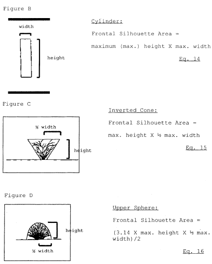
(iii) Vegetative Density Factor. Cut a single, representative piece of vegetation (or consolidated vegetative structure) to within 1 cm of surface soil. Using a white paper grid or transparent grid over white paper, lay the vegetation flat on top of the grid (but do not apply pressure to flatten the structure). Grid boxes of one inch or one half inch squares are sufficient for most vegetation when conducting this procedure. Using a marker or pencil, outline the shape of the vegetation along its outer perimeter according to Figure B, C or D of this appendix, as appropriate. (Note: Figure C differs from Figure D primarily in that the width of vegetation in Figure C is narrow at its base and gradually broadens to its tallest height. In Figure D, the width of the vegetation generally becomes narrower from its midpoint to its tallest height.) Remove the vegetation and count and record the total number of gridline intersections within the outlined area, but do not count gridline intersections that connect with the outlined shape. There must be at least 10 gridline intersections within the outlined area and preferably more than 20, otherwise, use smaller grid boxes. Draw small circles (no greater than a 3/32 inch diameter) at each gridline intersection counted within the outlined area. Replace the vegetation on the grid within its outlined shape. From a distance of approximately two feet directly above the grid, observe each circled gridline intersection. Count and record the number of circled gridline intersections that are not covered by any piece of the vegetation. To calculate percent vegetative density, use Equations 10 and 11 of this appendix. If percent vegetative density is equal to or greater than 30, use the equation (Eq. 14, 15 or 16) that matches the outline used to trace the vegetation (Figure B, C or D) to calculate its Frontal Silhouette Area. If percent vegetative density is less than 30, use Equations 12 and 13 of this appendix to calculate the Frontal Silhouette Area.
(iv) Within a disturbed surface area that contains multiple types of vegetation with each vegetation type uniformly distributed, results of the percent cover associated with the individual vegetation types may be added together.
(v) Repeat this procedure on an additional two (2) distinct survey areas representing the disturbed surface and average the results.
Height × Width = Frontal Silhouette Area Eq. 6 (Frontal Silhouette Area of Individual Vegetative Structure) × Number of Vegetation Structures Per Group = Group Frontal Silhouette Area of Group Eq. 7 Frontal Silhouette Area of Group 1 + Frontal Silhouette Area of Group 2 (etc.) = Total Frontal Silhouette Area Eq. 8 (Total Frontal Silhouette Area/Survey Area) × 100 = Percent Cover of Standing Vegetation Eq. 9 [(Number of circled gridlines within the outlined area counted that are not covered by vegetation / Total number of gridline intersections within the outlined area) × 100] = Percent Open Space Eq. 10 100 = Percent Open Space = Percent Vegetative Density Eq. 11 Percent Vegetative Density/100 = Vegetative Density Eq. 12
 Alternative Test
Methods
Alternative Test
Methods
Alternative test methods may be used upon obtaining the written approval of the EPA.
[64 FR 71308, Dec. 21, 1999]