Appendix C to Part 112 - Substantial Harm Criteria
40:24.0.1.1.7.4.6.3.3 : Appendix C
Appendix C to Part 112 - Substantial Harm Criteria 1.0 Introduction
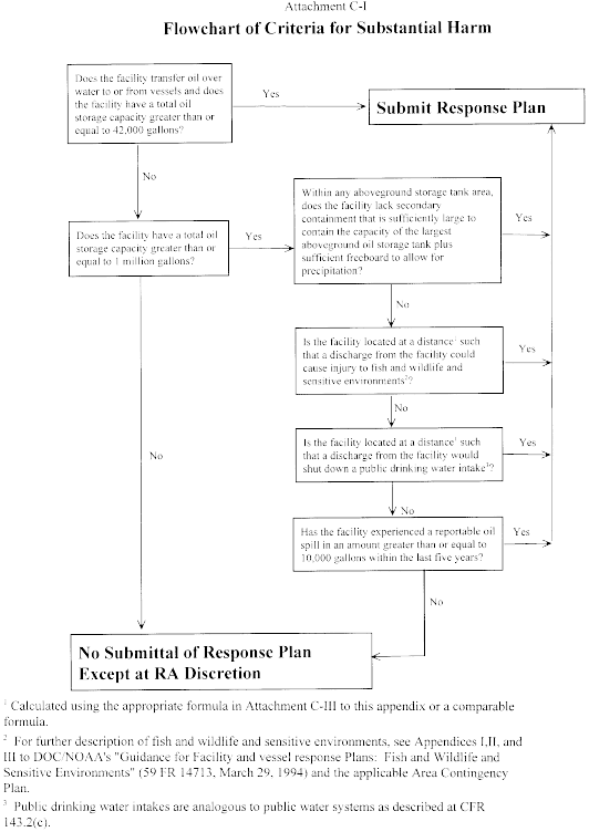
The flowchart provided in Attachment C-I to this appendix shows
the decision tree with the criteria to identify whether a facility
“could reasonably be expected to cause substantial harm to the
environment by discharging into or on the navigable waters or
adjoining shorelines.” In addition, the Regional Administrator has
the discretion to identify facilities that must prepare and submit
facility-specific response plans to EPA.
1.1 Definitions
1.1.1 Great Lakes means Lakes Superior, Michigan, Huron,
Erie, and Ontario, their connecting and tributary waters, the Saint
Lawrence River as far as Saint Regis, and adjacent port areas.
1.1.2 Higher Volume Port Areas include
(1) Boston, MA;
(2) New York, NY;
(3) Delaware Bay and River to Philadelphia, PA;
(4) St. Croix, VI;
(5) Pascagoula, MS;
(6) Mississippi River from Southwest Pass, LA to Baton Rouge,
LA;
(7) Louisiana Offshore Oil Port (LOOP), LA;
(8) Lake Charles, LA;
(9) Sabine-Neches River, TX;
(10) Galveston Bay and Houston Ship Channel, TX;
(11) Corpus Christi, TX;
(12) Los Angeles/Long Beach Harbor, CA;
(13) San Francisco Bay, San Pablo Bay, Carquinez Strait, and
Suisun Bay to Antioch, CA;
(14) Straits of Juan de Fuca from Port Angeles, WA to and
including Puget Sound, WA;
(15) Prince William Sound, AK; and
(16) Others as specified by the Regional Administrator for any
EPA Region.
1.1.3 Inland Area means the area shoreward of the
boundary lines defined in 46 CFR part 7, except in the Gulf of
Mexico. In the Gulf of Mexico, it means the area shoreward of the
lines of demarcation (COLREG lines as defined in 33 CFR
80.740-80.850). The inland area does not include the Great
Lakes.
1.1.4 Rivers and Canals means a body of water confined
within the inland area, including the Intracoastal Waterways and
other waterways artificially created for navigating that have
project depths of 12 feet or less.
2.0 Description of Screening Criteria for the Substantial Harm
Flowchart
A facility that has the potential to cause substantial harm to
the environment in the event of a discharge must prepare and submit
a facility-specific response plan to EPA in accordance with
appendix F to this part. A description of the screening criteria
for the substantial harm flowchart is provided below:
2.1 Non-Transportation-Related Facilities With a Total Oil
Storage Capacity Greater Than or Equal to 42,000 Gallons Where
Operations Include Over-Water Transfers of Oil. A
non-transportation-related facility with a total oil storage
capacity greater than or equal to 42,000 gallons that transfers oil
over water to or from vessels must submit a response plan to EPA.
Daily oil transfer operations at these types of facilities occur
between barges and vessels and onshore bulk storage tanks over open
water. These facilities are located adjacent to navigable
water.
2.2 Lack of Adequate Secondary Containment at Facilities With
a Total Oil Storage Capacity Greater Than or Equal to 1 Million
Gallons. Any facility with a total oil storage capacity greater
than or equal to 1 million gallons without secondary containment
sufficiently large to contain the capacity of the largest
aboveground oil storage tank within each area plus sufficient
freeboard to allow for precipitation must submit a response plan to
EPA. Secondary containment structures that meet the standard of
good engineering practice for the purposes of this part include
berms, dikes, retaining walls, curbing, culverts, gutters, or other
drainage systems.
2.3 Proximity to Fish and Wildlife and Sensitive Environments
at Facilities With a Total Oil Storage Capacity Greater Than or
Equal to 1 Million Gallons. A facility with a total oil storage
capacity greater than or equal to 1 million gallons must submit its
response plan if it is located at a distance such that a discharge
from the facility could cause injury (as defined at 40 CFR 112.2)
to fish and wildlife and sensitive environments. For further
description of fish and wildlife and sensitive environments, see
Appendices I, II, and III to DOC/NOAA's “Guidance for Facility and
Vessel Response Plans: Fish and Wildlife and Sensitive
Environments” (see appendix E to this part, section 13, for
availability) and the applicable Area Contingency Plan. Facility
owners or operators must determine the distance at which an oil
discharge could cause injury to fish and wildlife and sensitive
environments using the appropriate formula presented in Attachment
C-III to this appendix or a comparable formula.
2.4 Proximity to Public Drinking Water Intakes at Facilities
with a Total Oil Storage Capacity Greater than or Equal to 1
Million Gallons A facility with a total oil storage capacity
greater than or equal to 1 million gallons must submit its response
plan if it is located at a distance such that a discharge from the
facility would shut down a public drinking water intake, which is
analogous to a public water system as described at 40 CFR 143.2(c).
The distance at which an oil discharge from an SPCC-regulated
facility would shut down a public drinking water intake shall be
calculated using the appropriate formula presented in Attachment
C-III to this appendix or a comparable formula.
2.5 Facilities That Have Experienced Reportable Oil
Discharges in an Amount Greater Than or Equal to 10,000 Gallons
Within the Past 5 Years and That Have a Total Oil Storage Capacity
Greater Than or Equal to 1 Million Gallons. A facility's oil
spill history within the past 5 years shall be considered in the
evaluation for substantial harm. Any facility with a total oil
storage capacity greater than or equal to 1 million gallons that
has experienced a reportable oil discharge in an amount greater
than or equal to 10,000 gallons within the past 5 years must submit
a response plan to EPA.
3.0 Certification for Facilities That Do Not Pose Substantial Harm
If the facility does not meet the substantial harm criteria
listed in Attachment C-I to this appendix, the owner or operator
shall complete and maintain at the facility the certification form
contained in Attachment C-II to this appendix. In the event an
alternative formula that is comparable to the one in this appendix
is used to evaluate the substantial harm criteria, the owner or
operator shall attach documentation to the certification form that
demonstrates the reliability and analytical soundness of the
comparable formula and shall notify the Regional Administrator in
writing that an alternative formula was used.
4.0 References
Chow, V.T. 1959. Open Channel Hydraulics. McGraw Hill.
USCG IFR (58 FR 7353, February 5, 1993). This document is
available through EPA's rulemaking docket as noted in appendix E to
this part, section 13.
Attachments to Appendix C
Attachment C-II -
Certification of the Applicability of the Substantial Harm Criteria
Facility Name: Facility Address:
1. Does the facility transfer oil over water to or from vessels
and does the facility have a total oil storage capacity greater
than or equal to 42,000 gallons?
Yes __ No __
2. Does the facility have a total oil storage capacity greater
than or equal to 1 million gallons and does the facility lack
secondary containment that is sufficiently large to contain the
capacity of the largest aboveground oil storage tank plus
sufficient freeboard to allow for precipitation within any
aboveground oil storage tank area?
Yes __ No __
3. Does the facility have a total oil storage capacity greater
than or equal to 1 million gallons and is the facility located at a
distance (as calculated using the appropriate formula in Attachment
C-III to this appendix or a comparable formula 1) such that a
discharge from the facility could cause injury to fish and wildlife
and sensitive environments? For further description of fish and
wildlife and sensitive environments, see Appendices I, II, and III
to DOC/NOAA's “Guidance for Facility and Vessel Response Plans:
Fish and Wildlife and Sensitive Environments” (see appendix E to
this part, section 13, for availability) and the applicable Area
Contingency Plan.
Yes __ No __
4. Does the facility have a total oil storage capacity greater
than or equal to 1 million gallons and is the facility located at a
distance (as calculated using the appropriate formula in Attachment
C-III to this appendix or a comparable formula 1 ) such that a
discharge from the facility would shut down a public drinking water
intake? 2
1 If a comparable formula is used, documentation of the
reliability and analytical soundness of the comparable formula must
be attached to this form.
2 For the purposes of 40 CFR part 112, public drinking water
intakes are analogous to public water systems as described at 40
CFR 143.2(c).
Yes __ No __
5. Does the facility have a total oil storage capacity greater
than or equal to 1 million gallons and has the facility experienced
a reportable oil discharge in an amount greater than or equal to
10,000 gallons within the last 5 years?
Yes __ No __
Certification
I certify under penalty of law that I have personally examined
and am familiar with the information submitted in this document,
and that based on my inquiry of those individuals responsible for
obtaining this information, I believe that the submitted
information is true, accurate, and complete.
Signature Name (please type or print) Title Date Attachment C-III -
Calculation of the Planning Distance 1.0 Introduction
1.1 The facility owner or operator must evaluate whether the
facility is located at a distance such that a discharge from the
facility could cause injury to fish and wildlife and sensitive
environments or disrupt operations at a public drinking water
intake. To quantify that distance, EPA considered oil transport
mechanisms over land and on still, tidal influence, and moving
navigable waters. EPA has determined that the primary concern for
calculation of a planning distance is the transport of oil in
navigable waters during adverse weather conditions. Therefore, two
formulas have been developed to determine distances for planning
purposes from the point of discharge at the facility to the
potential site of impact on moving and still waters, respectively.
The formula for oil transport on moving navigable water is based on
the velocity of the water body and the time interval for arrival of
response resources. The still water formula accounts for the spread
of discharged oil over the surface of the water. The method to
determine oil transport on tidal influence areas is based on the
type of oil discharged and the distance down current during ebb
tide and up current during flood tide to the point of maximum tidal
influence.
1.2 EPA's formulas were designed to be simple to use. However,
facility owners or operators may calculate planning distances using
more sophisticated formulas, which take into account broader
scientific or engineering principles, or local conditions. Such
comparable formulas may result in different planning distances than
EPA's formulas. In the event that an alternative formula that is
comparable to one contained in this appendix is used to evaluate
the criterion in 40 CFR 112.20(f)(1)(ii)(B) or (f)(1)(ii)(C), the
owner or operator shall attach documentation to the response plan
cover sheet contained in appendix F to this part that demonstrates
the reliability and analytical soundness of the alternative formula
and shall notify the Regional Administrator in writing that an
alternative formula was used. 1
1 For persistent oils or non-persistent oils, a worst case
trajectory model (i.e., an alternative formula) may be substituted
for the distance formulas described in still, moving, and tidal
waters, subject to Regional Administrator's review of the model. An
example of an alternative formula that is comparable to the one
contained in this appendix would be a worst case trajectory
calculation based on credible adverse winds, currents, and/or river
stages, over a range of seasons, weather conditions, and river
stages. Based on historical information or a spill trajectory
model, the Agency may require that additional fish and wildlife and
sensitive environments or public drinking water intakes also be
protected.
1.3 A regulated facility may meet the criteria for the potential
to cause substantial harm to the environment without having to
perform a planning distance calculation. For facilities that meet
the substantial harm criteria because of inadequate secondary
containment or oil spill history, as listed in the flowchart in
Attachment C-I to this appendix, calculation of the planning
distance is unnecessary. For facilities that do not meet the
substantial harm criteria for secondary containment or oil spill
history as listed in the flowchart, calculation of a planning
distance for proximity to fish and wildlife and sensitive
environments and public drinking water intakes is required, unless
it is clear without performing the calculation (e.g., the facility
is located in a wetland) that these areas would be impacted.
1.4 A facility owner or operator who must perform a planning
distance calculation on navigable water is only required to do so
for the type of navigable water conditions (i.e., moving water,
still water, or tidal- influenced water) applicable to the
facility. If a facility owner or operator determines that more than
one type of navigable water condition applies, then the facility
owner or operator is required to perform a planning distance
calculation for each navigable water type to determine the greatest
single distance that oil may be transported. As a result, the final
planning distance for oil transport on water shall be the greatest
individual distance rather than a summation of each calculated
planning distance.
1.5 The planning distance formula for transport on moving
waterways contains three variables: the velocity of the navigable
water (v), the response time interval (t), and a conversion factor
(c). The velocity, v, is determined by using the Chezy-Manning
equation, which, in this case, models the flood flow rate of water
in open channels. The Chezy-Manning equation contains three
variables which must be determined by facility owners or operators.
Manning's Roughness Coefficient (for flood flow rates), n, can be
determined from Table 1 of this attachment. The hydraulic radius,
r, can be estimated using the average mid-channel depth from charts
provided by the sources listed in Table 2 of this attachment. The
average slope of the river, s, can be determined using topographic
maps that can be ordered from the U.S. Geological Survey, as listed
in Table 2 of this attachment.
1.6 Table 3 of this attachment contains specified time intervals
for estimating the arrival of response resources at the scene of a
discharge. Assuming no prior planning, response resources should be
able to arrive at the discharge site within 12 hours of the
discovery of any oil discharge in Higher Volume Port Areas and
within 24 hours in Great Lakes and all other river, canal, inland,
and nearshore areas. The specified time intervals in Table 3 of
appendix C are to be used only to aid in the identification of
whether a facility could cause substantial harm to the environment.
Once it is determined that a plan must be developed for the
facility, the owner or operator shall reference appendix E to this
part to determine appropriate resource levels and response times.
The specified time intervals of this appendix include a 3-hour time
period for deployment of boom and other response equipment. The
Regional Administrator may identify additional areas as
appropriate.
2.0 Oil Transport on Moving Navigable Waters
2.1 The facility owner or operator must use the following
formula or a comparable formula as described in § 112.20(a)(3) to
calculate the planning distance for oil transport on moving
navigable water:
d = v × t × c; where d: the distance downstream from a facility
within which fish and wildlife and sensitive environments could be
injured or a public drinking water intake would be shut down in the
event of an oil discharge (in miles); v: the velocity of the
river/navigable water of concern (in ft/sec) as determined by
Chezy-Manning's equation (see below and Tables 1 and 2 of this
attachment); t: the time interval specified in Table 3 based upon
the type of water body and location (in hours); and c: constant
conversion factor 0.68 secω mile/hrω ft (3600 sec/hr ÷ 5280
ft/mile).
2.2 Chezy-Manning's equation is used to determine velocity:
v = 1.5/n × r 2/3 × s 1/2; where v = the velocity of the river of
concern (in ft/sec); n = Manning's Roughness Coefficient from Table
1 of this attachment; r = the hydraulic radius; the hydraulic
radius can be approximated for parabolic channels by multiplying
the average mid-channel depth of the river (in feet) by 0.667
(sources for obtaining the mid-channel depth are listed in Table 2
of this attachment); and s = the average slope of the river
(unitless) obtained from U.S. Geological Survey topographic maps at
the address listed in Table 2 of this attachment.
Table 1 - Manning's Roughness Coefficient
for Natural Streams
[Note: Coefficients are presented for
high flow rates at or near flood stage.]
| Stream description |
Roughness coefficient
(n) |
| Minor Streams
(Top Width <100 ft.) |
|
| Clean: |
|
| Straight |
0.03 |
| Winding |
0.04 |
| Sluggish (Weedy,
deep pools): |
|
| No trees or
brush |
0.06 |
| Trees and/or
brush |
0.10 |
| Major Streams
(Top Width >100 ft.) |
|
| Regular
section: |
|
| (No
boulders/brush) |
0.035 |
| Irregular
section: |
|
| (Brush) |
0.05 |
Table 2 - Sources of r and s for the Chezy-Manning Equation All of
the charts and related publications for navigational waters may be
ordered from: Distribution Branch (N/CG33) National Ocean Service
Riverdale, Maryland 20737-1199 Phone: (301) 436-6990 There will be
a charge for materials ordered and a VISA or Mastercard will be
accepted. The mid-channel depth to be used in the calculation of
the hydraulic radius (r) can be obtained directly from the
following sources: Charts of Canadian Coastal and Great Lakes
Waters: Canadian Hydrographic Service Department of Fisheries and
Oceans Institute P.O. Box 8080 1675 Russell Road Ottawa, Ontario
KIG 3H6 Canada Phone: (613) 998-4931 Charts and Maps of Lower
Mississippi River (Gulf of Mexico to Ohio River and St. Francis,
White, Big Sunflower, Atchafalaya, and other rivers): U.S. Army
Corps of Engineers Vicksburg District P.O. Box 60 Vicksburg,
Mississippi 39180 Phone: (601) 634-5000 Charts of Upper Mississippi
River and Illinois Waterway to Lake Michigan: U.S. Army Corps of
Engineers Rock Island District P.O. Box 2004 Rock Island, Illinois
61204 Phone: (309) 794-5552 Charts of Missouri River: U.S. Army
Corps of Engineers Omaha District 6014 U.S. Post Office and
Courthouse Omaha, Nebraska 68102 Phone: (402) 221-3900 Charts of
Ohio River: U.S. Army Corps of Engineers Ohio River Division P.O.
Box 1159 Cincinnati, Ohio 45201 Phone: (513) 684-3002 Charts of
Tennessee Valley Authority Reservoirs, Tennessee River and
Tributaries: Tennessee Valley Authority Maps and Engineering
Section 416 Union Avenue Knoxville, Tennessee 37902 Phone: (615)
632-2921 Charts of Black Warrior River, Alabama River, Tombigbee
River, Apalachicola River and Pearl River: U.S. Army Corps of
Engineers Mobile District P.O. Box 2288 Mobile, Alabama 36628-0001
Phone: (205) 690-2511 The average slope of the river (s) may be
obtained from topographic maps: U.S. Geological Survey Map
Distribution Federal Center Bldg. 41 Box 25286 Denver, Colorado
80225 Additional information can be obtained from the following
sources: 1. The State's Department of Natural Resources (DNR) or
the State's Aids to Navigation office; 2. A knowledgeable local
marina operator; or 3. A knowledgeable local water authority (e.g.,
State water commission)
2.3 The average slope of the river (s) can be determined from
the topographic maps using the following steps:
(1) Locate the facility on the map.
(2) Find the Normal Pool Elevation at the point of discharge
from the facility into the water (A).
(3) Find the Normal Pool Elevation of the public drinking water
intake or fish and wildlife and sensitive environment located
downstream (B) (Note: The owner or operator should use a minimum of
20 miles downstream as a cutoff to obtain the average slope if the
location of a specific public drinking water intake or fish and
wildlife and sensitive environment is unknown).
(4) If the Normal Pool Elevation is not available, the elevation
contours can be used to find the slope. Determine elevation of the
water at the point of discharge from the facility (A). Determine
the elevation of the water at the appropriate distance downstream
(B). The formula presented below can be used to calculate the
slope.
(5) Determine the distance (in miles) between the facility and
the public drinking water intake or fish and wildlife and sensitive
environments (C).
(6) Use the following formula to find the slope, which will be a
unitless value: Average Slope=[(A−B) (ft)/C (miles)] × [1 mile/5280
feet]
2.4 If it is not feasible to determine the slope and mid-channel
depth by the Chezy-Manning equation, then the river velocity can be
approximated on- site. A specific length, such as 100 feet, can be
marked off along the shoreline. A float can be dropped into the
stream above the mark, and the time required for the float to
travel the distance can be used to determine the velocity in feet
per second. However, this method will not yield an average velocity
for the length of the stream, but a velocity only for the specific
location of measurement. In addition, the flow rate will vary
depending on weather conditions such as wind and rainfall. It is
recommended that facility owners or operators repeat the
measurement under a variety of conditions to obtain the most
accurate estimate of the surface water velocity under adverse
weather conditions.
2.5 The planning distance calculations for moving and still
navigable waters are based on worst case discharges of persistent
oils. Persistent oils are of concern because they can remain in the
water for significant periods of time and can potentially exist in
large quantities downstream. Owners or operators of facilities that
store persistent as well as non-persistent oils may use a
comparable formula. The volume of oil discharged is not included as
part of the planning distance calculation for moving navigable
waters. Facilities that will meet this substantial harm criterion
are those with facility capacities greater than or equal to 1
million gallons. It is assumed that these facilities are capable of
having an oil discharge of sufficient quantity to cause injury to
fish and wildlife and sensitive environments or shut down a public
drinking water intake. While owners or operators of transfer
facilities that store greater than or equal to 42,000 gallons are
not required to use a planning distance formula for purposes of the
substantial harm criteria, they should use a planning distance
calculation in the development of facility-specific response
plans.
Table 3 - Specified Time Intervals
| Operating areas |
Substantial harm planning
time (hrs) |
| Higher volume port
area |
12 hour arrival + 3 hour
deployment = 15 hours. |
| Great Lakes |
24 hour arrival + 3 hour
deployment = 27 hours. |
| All other rivers
and canals, inland, and nearshore areas |
24 hour arrival + 3 hour
deployment = 27 hours. |
2.6 Example of the Planning Distance Calculation for Oil
Transport on Moving Navigable Waters. The following example
provides a sample calculation using the planning distance formula
for a facility discharging oil into the Monongahela River:
(1) Solve for v by evaluating n, r, and s for the Chezy-Manning
equation:
Find the roughness coefficient, n, on Table 1 of this attachment
for a regular section of a major stream with a top width greater
than 100 feet. The top width of the river can be found from the
topographic map.
n = 0.035. Find slope, s, where A = 727 feet, B = 710 feet, and C =
25 miles. Solving: s = [(727 ft − 1710 ft) / 25 miles] × [1
mile/5280 feet] = 1.3 × 10⁻⁴
The average mid-channel depth is found by averaging the
mid-channel depth for each mile along the length of the river
between the facility and the public drinking water intake or the
fish or wildlife or sensitive environment (or 20 miles downstream
if applicable). This value is multiplied by 0.667 to obtain the
hydraulic radius. The mid-channel depth is found by obtaining
values for r and s from the sources shown in Table 2 for the
Monongahela River.
Solving: r = 0.667 × 20 feet = 13.33 feet Solve for v using: v =
1.5/n × r 2/3 × s 1/2: v = [1.5/0.035] × (13.33) 2/3 × (1.3 × 10−4)
1/2 v = 2.73 feet/second
(2) Find t from Table 3 of this attachment. The Monongahela
River's resource response time is 27 hours.
(3) Solve for planning distance, d:
d = v × t × c d = (2.73 ft/sec) × (27 hours) × (0.68 secω mile/hrω
ft) d = 50 miles Therefore, 50 miles downstream is the appropriate
planning distance for this facility. 3.0 Oil Transport on Still
Water
3.1 For bodies of water including lakes or ponds that do not
have a measurable velocity, the spreading of the oil over the
surface must be considered. Owners or operators of facilities
located next to still water bodies may use a comparable means of
calculating the planning distance. If a comparable formula is used,
documentation of the reliability and analytical soundness of the
comparable calculation must be attached to the response plan cover
sheet.
3.2 Example of the Planning Distance Calculation for Oil
Transport on Still Water. To assist those facilities which
could potentially discharge into a still body of water, the
following analysis was performed to provide an example of the type
of formula that may be used to calculate the planning distance. For
this example, a worst case discharge of 2,000,000 gallons is
used.
(1) The surface area in square feet covered by an oil discharge
on still water, A1, can be determined by the following formula, 2
where V is the volume of the discharge in gallons and C is a
constant conversion factor:
2 Huang, J.C. and Monastero, F.C., 1982. Review of the
State-of-the-Art of Oil Pollution Models. Final report
submitted to the American Petroleum Institute by Raytheon Ocean
Systems, Co., East Providence, Rhode Island.
A1 = 10 5 × V 3/4 × C C = 0.1643 A1 = 10 5 × (2,000,000 gallons)
3/4 × (0.1643) A1 = 8.74 × 10 8 ft 2
(2) The spreading formula is based on the theoretical condition
that the oil will spread uniformly in all directions forming a
circle. In reality, the outfall of the discharge will direct the
oil to the surface of the water where it intersects the shoreline.
Although the oil will not spread uniformly in all directions, it is
assumed that the discharge will spread from the shoreline into a
semi-circle (this assumption does not account for winds or wave
action).
(3) The area of a circle=† r 2
(4) To account for the assumption that oil will spread in a
semi-circular shape, the area of a circle is divided by 2 and is
designated as A2.
A2 = († r 2)/2 Solving for the radius, r, using the relationship A1
= A2: 8.74 × 10 8 ft 2 = († 2)/2 Therefore, r = 23,586 ft r =
23,586 ft ÷ 5,280 ft/mile = 4.5 miles Assuming a 20 knot wind under
storm conditions: 1 knot = 1.15 miles/hour 20 knots × 1.15
miles/hour/knot = 23 miles/hr Assuming that the oil slick moves at
3 percent of the wind's speed: 3
3 Oil Spill Prevention & Control. National Spill Control
School, Corpus Christi State University, Thirteenth Edition, May
1990.
23 miles/hour × 0.03 = 0.69 miles/hour
(5) To estimate the distance that the oil will travel, use the
times required for response resources to arrive at different
geographic locations as shown in Table 3 of this attachment.
For example: For Higher Volume Port Areas: 15 hrs × 0.69 miles/hr =
10.4 miles For Great Lakes and all other areas: 27 hrs × 0.69
miles/hr = 18.6 miles
(6) The total distance that the oil will travel from the point
of discharge, including the distance due to spreading, is
calculated as follows:
Higher Volume Port Areas: d = 10.4 + 4.5 miles or approximately 15
miles Great Lakes and all other areas: d = 18.6 + 4.5 miles or
approximately 23 miles 4.0 Oil Transport on Tidal-Influence Areas
4.1 The planning distance method for tidal influence navigable
water is based on worst case discharges of persistent and
non-persistent oils. Persistent oils are of primary concern because
they can potentially cause harm over a greater distance. For
persistent oils discharged into tidal waters, the planning distance
is 15 miles from the facility down current during ebb tide and to
the point of maximum tidal influence or 15 miles, whichever is
less, during flood tide.
4.2 For non-persistent oils discharged into tidal waters, the
planning distance is 5 miles from the facility down current during
ebb tide and to the point of maximum tidal influence or 5 miles,
whichever is less, during flood tide.
4.3 Example of Determining the Planning Distance for Two
Types of Navigable Water Conditions. Below is an example of how
to determine the proper planning distance when a facility could
impact two types of navigable water conditions: moving water and
tidal water.
(1) Facility X stores persistent oil and is located downstream
from locks along a slow moving river which is affected by tides.
The river velocity, v, is determined to be 0.5 feet/second from the
Chezy-Manning equation used to calculate oil transport on moving
navigable waters. The specified time interval, t, obtained from
Table 3 of this attachment for river areas is 27 hours. Therefore,
solving for the planning distance, d:
d = v × t × c d = (0.5 ft/sec) × (27 hours) × (0.68 secmile/hrft) d
= 9.18 miles.
(2) However, the planning distance for maximum tidal influence
down current during ebb tide is 15 miles, which is greater than the
calculated 9.18 miles. Therefore, 15 miles downstream is the
appropriate planning distance for this facility.
5.0 Oil Transport Over Land
5.1 Facility owners or operators must evaluate the potential for
oil to be transported over land to navigable waters of the United
States. The owner or operator must evaluate the likelihood that
portions of a worst case discharge would reach navigable waters via
open channel flow or from sheet flow across the land, or be
prevented from reaching navigable waters when trapped in natural or
man-made depressions excluding secondary containment
structures.
5.2 As discharged oil travels over land, it may enter a storm
drain or open concrete channel intended for drainage. It is assumed
that once oil reaches such an inlet, it will flow into the
receiving navigable water. During a storm event, it is highly
probable that the oil will either flow into the drainage structures
or follow the natural contours of the land and flow into the
navigable water. Expected minimum and maximum velocities are
provided as examples of open concrete channel and pipe flow. The
ranges listed below reflect minimum and maximum velocities used as
design criteria. 4 The calculation below demonstrates that the time
required for oil to travel through a storm drain or open concrete
channel to navigable water is negligible and can be considered
instantaneous. The velocities are:
4 The design velocities were obtained from Howard County,
Maryland Department of Public Works' Storm Drainage Design
Manual.
For open concrete channels: maximum velocity = 25 feet per second
minimum velocity = 3 feet per second For storm drains: maximum
velocity = 25 feet per second minimum velocity = 2 feet per second
5.3 Assuming a length of 0.5 mile from the point of discharge
through an open concrete channel or concrete storm drain to a
navigable water, the travel times (distance/velocity) are:
1.8 minutes at a velocity of 25 feet per second 14.7 minutes at a
velocity of 3 feet per second 22.0 minutes for at a velocity of 2
feet per second
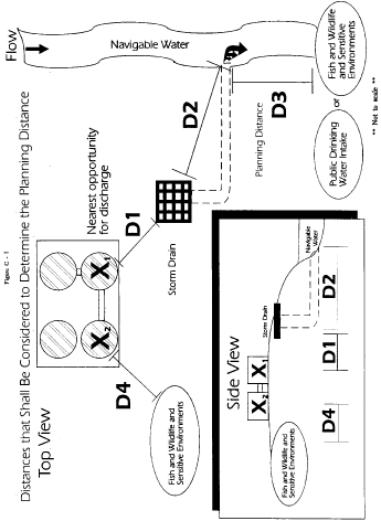
5.4 The distances that shall be considered to determine the
planning distance are illustrated in Figure C-I of this attachment.
The relevant distances can be described as follows:
D1 = Distance from the nearest opportunity for discharge, X1, to a
storm drain or an open concrete channel leading to navigable water.
D2 = Distance through the storm drain or open concrete channel to
navigable water. D3 = Distance downstream from the outfall within
which fish and wildlife and sensitive environments could be injured
or a public drinking water intake would be shut down as determined
by the planning distance formula. D4 = Distance from the nearest
opportunity for discharge, X2, to fish and wildlife and sensitive
environments not bordering navigable water.
5.5 A facility owner or operator whose nearest opportunity for
discharge is located within 0.5 mile of a navigable water must
complete the planning distance calculation (D3) for the type of
navigable water near the facility or use a comparable formula.
5.6 A facility that is located at a distance greater than 0.5
mile from a navigable water must also calculate a planning distance
(D3) if it is in close proximity (i.e., D1 is less than 0.5 mile
and other factors are conducive to oil travel over land) to storm
drains that flow to navigable waters. Factors to be considered in
assessing oil transport over land to storm drains shall include the
topography of the surrounding area, drainage patterns, man-made
barriers (excluding secondary containment structures), and soil
distribution and porosity. Storm drains or concrete drainage
channels that are located in close proximity to the facility can
provide a direct pathway to navigable waters, regardless of the
length of the drainage pipe. If D1 is less than or equal to 0.5
mile, a discharge from the facility could pose substantial harm
because the time to travel the distance from the storm drain to the
navigable water (D2) is virtually instantaneous.
5.7 A facility's proximity to fish and wildlife and sensitive
environments not bordering a navigable water, as depicted as D4 in
Figure C-I of this attachment, must also be considered, regardless
of the distance from the facility to navigable waters. Factors to
be considered in assessing oil transport over land to fish and
wildlife and sensitive environments should include the topography
of the surrounding area, drainage patterns, man-made barriers
(excluding secondary containment structures), and soil distribution
and porosity.
5.8 If a facility is not found to pose substantial harm to fish
and wildlife and sensitive environments not bordering navigable
waters via oil transport on land, then supporting documentation
should be maintained at the facility. However, such documentation
should be submitted with the response plan if a facility is found
to pose substantial harm.
[59 FR
34102, July 1, 1994, as amended at 65 FR 40798, June 30, 2000; 67
FR 47152, July 17, 2002]