Title 15
PART 922 APPENDIX a
| Point | Latitude (N) | Longitude (W) |
|---|---|---|
| 1 | 33.94138 | −119.27422 |
| 2 | 33.96776 | −119.25010 |
| 3 | 34.02607 | −119.23642 |
| 4 | 34.07339 | −119.25686 |
| 5 | 34.10185 | −119.29178 |
| 6 | 34.11523 | −119.33040 |
| 7 | 34.11611 | −119.39120 |
| 8 | 34.11434 | −119.40212 |
| 9 | 34.11712 | −119.42896 |
| 10 | 34.11664 | −119.44844 |
| 11 | 34.13389 | −119.48081 |
| 12 | 34.13825 | −119.49198 |
| 13 | 34.14784 | −119.51194 |
| 14 | 34.15086 | −119.54670 |
| 15 | 34.15450 | −119.54670 |
| 16 | 34.15450 | −119.59170 |
| 17 | 34.15142 | −119.61254 |
| 18 | 34.13411 | −119.66024 |
| 19 | 34.14635 | −119.69780 |
| 20 | 34.15988 | −119.76688 |
| 21 | 34.15906 | −119.77800 |
| 22 | 34.15928 | −119.79327 |
| 23 | 34.16213 | −119.80347 |
| 24 | 34.16962 | −119.83643 |
| 25 | 34.17266 | −119.85240 |
| 26 | 34.17588 | −119.88903 |
| 27 | 34.17682 | −119.93357 |
| 28 | 34.17258 | −119.95830 |
| 29 | 34.13535 | −120.01964 |
| 30 | 34.13698 | −120.04206 |
| 31 | 34.12994 | −120.08582 |
| 32 | 34.12481 | −120.11104 |
| 33 | 34.12519 | −120.16076 |
| 34 | 34.11008 | −120.21190 |
| 35 | 34.11128 | −120.22707 |
| 36 | 34.13632 | −120.25292 |
| 37 | 34.15341 | −120.28627 |
| 38 | 34.16408 | −120.29310 |
| 39 | 34.17704 | −120.30670 |
| 40 | 34.20492 | −120.30670 |
| 41 | 34.20492 | −120.38830 |
| 42 | 34.20707 | −120.41801 |
| 43 | 34.20520 | −120.42859 |
| 44 | 34.19254 | −120.46041 |
| 45 | 34.20540 | −120.50728 |
| 46 | 34.20486 | −120.53987 |
| 47 | 34.18182 | −120.60041 |
| 48 | 34.10208 | −120.64208 |
| 49 | 34.08151 | −120.63894 |
| 50 | 34.05848 | −120.62862 |
| 51 | 34.01940 | −120.58567 |
| 52 | 34.01349 | −120.57464 |
| 53 | 33.98698 | −120.56582 |
| 54 | 33.95039 | −120.53282 |
| 55 | 33.92694 | −120.46132 |
| 56 | 33.92501 | −120.42170 |
| 57 | 33.91403 | −120.37585 |
| 58 | 33.91712 | −120.32506 |
| 59 | 33.90956 | −120.30857 |
| 60 | 33.88976 | −120.29540 |
| 61 | 33.84444 | −120.25482 |
| 62 | 33.83146 | −120.22927 |
| 63 | 33.81763 | −120.20284 |
| 64 | 33.81003 | −120.18731 |
| 65 | 33.79425 | −120.13422 |
| 66 | 33.79379 | −120.10207 |
| 67 | 33.79983 | −120.06995 |
| 68 | 33.81076 | −120.04351 |
| 69 | 33.81450 | −120.03158 |
| 70 | 33.84125 | −119.96508 |
| 71 | 33.84865 | −119.92316 |
| 72 | 33.86993 | −119.88330 |
| 73 | 33.86195 | −119.88330 |
| 74 | 33.86195 | −119.80000 |
| 75 | 33.86110 | −119.79017 |
| 76 | 33.86351 | −119.77130 |
| 77 | 33.85995 | −119.74390 |
| 78 | 33.86233 | −119.68783 |
| 79 | 33.87330 | −119.65504 |
| 80 | 33.88594 | −119.62617 |
| 81 | 33.88688 | −119.59423 |
| 82 | 33.88809 | −119.58278 |
| 83 | 33.89414 | −119.54861 |
| 84 | 33.90064 | −119.51936 |
| 85 | 33.90198 | −119.51609 |
| 86 | 33.90198 | −119.43311 |
| 87 | 33.90584 | −119.43311 |
| 88 | 33.90424 | −119.42422 |
| 89 | 33.90219 | −119.40730 |
| 90 | 33.90131 | −119.38373 |
| 91 | 33.90398 | −119.36333 |
| 92 | 33.90635 | −119.35345 |
| 93 | 33.91304 | −119.33280 |
| 94 | 33.91829 | −119.32206 |
| 95 | 33.48250 | −119.16874 |
| 96 | 33.44235 | −119.16797 |
| 97 | 33.40555 | −119.14878 |
| 98 | 33.39059 | −119.13283 |
| 99 | 33.36804 | −119.08891 |
| 100 | 33.36375 | −119.06803 |
| 101 | 33.36241 | −119.04812 |
| 102 | 33.36320 | −119.03670 |
| 103 | 33.36320 | −118.90879 |
| 104 | 33.47500 | −118.90879 |
| 105 | 33.48414 | −118.90712 |
| 106 | 33.52444 | −118.91492 |
| 107 | 33.53834 | −118.92271 |
| 108 | 33.58616 | −118.99540 |
| 109 | 33.59018 | −119.02374 |
| 110 | 33.58516 | −119.06745 |
| 111 | 33.58011 | −119.08521 |
| 112 | 33.54367 | −119.14460 |
| 113 | 33.51161 | −119.16367 |
Appendix A to Subpart H of Part 922 - Greater Farallones National Marine Sanctuary Boundary Coordinates
15:3.1.2.2.13.8.17.7.8 : Appendix A
Appendix A to Subpart H of Part 922 - Greater Farallones National Marine Sanctuary Boundary CoordinatesCoordinates listed in this appendix are unprojected (Geographic) and based on the North American Datum of 1983.
| Point ID No. | Latitude | Longitude |
|---|---|---|
| 1 | 39.00000 | −124.33350 |
| 2 | 38.29989 | −123.99988 |
| 3 | 38.29989 | −123.20005 |
| 4 | 38.26390 | −123.18138 |
| 5 | 38.21001 | −123.11913 |
| 6 | 38.16576 | −123.09207 |
| 7 | 38.14072 | −123.08237 |
| 8 | 38.12829 | −123.08742 |
| 9 | 38.10215 | −123.09804 |
| 10 | 38.09069 | −123.10387 |
| 11 | 38.07898 | −123.10924 |
| 12 | 38.06505 | −123.11711 |
| 13 | 38.05202 | −123.12827 |
| 14 | 37.99227 | −123.14137 |
| 15 | 37.98947 | −123.23615 |
| 16 | 37.95880 | −123.32312 |
| 17 | 37.90464 | −123.38958 |
| 18 | 37.83480 | −123.42579 |
| 19 | 37.76687 | −123.42694 |
| 20 | 37.75932 | −123.42686 |
| 21 | 37.68892 | −123.39274 |
| 22 | 37.63356 | −123.32819 |
| 23 | 37.60123 | −123.24292 |
| 24 | 37.59165 | −123.22641 |
| 25 | 37.56305 | −123.19859 |
| 26 | 37.52001 | −123.12879 |
| 27 | 37.50819 | −123.09617 |
| 28 | 37.49418 | −123.00770 |
| 29 | 37.50948 | −122.90614 |
| 30 | 37.52988 | −122.85988 |
| 31 | 37.57147 | −122.80399 |
| 32 | 37.61622 | −122.76937 |
| 33 | 37.66641 | −122.75105 |
| 34 * | 37.88225 | −122.62753 |
| 35 * | 38.35045 | −123.06711 |
| 36 * | 38.35665 | −123.06724 |
| 37 * | 38.44575 | −123.12602 |
| 38 * | 38.45531 | −123.13469 |
| 39 * | 38.76231 | −123.52957 |
| 40 * | 38.76941 | −123.53541 |
| 41 * | 38.91136 | −123.71061 |
| 42 * | 38.91766 | −123.72568 |
| 43 * | 38.95404 | −123.73405 |
| 44 * | 38.95944 | −123.71820 |
| 45 * | 39.00000 | −123.69710 |
| 46 | 39.00000 | −124.33350 |
Note: The coordinates in the table above marked with an asterisk (*) are not a part of the sanctuary boundary. These coordinates are landward reference points used to draw a line segment that intersects with the shoreline.
Appendix A to Subpart I of Part 922 - Boundary Coordinates for the Gray's Reef National Marine Sanctuary Research Area
15:3.1.2.2.13.9.17.6.15 : Appendix A
Appendix A to Subpart I of Part 922 - Boundary Coordinates for the Gray's Reef National Marine Sanctuary Research Area[Coordinates listed in this Appendix are unprojected (Geographic) and based on the North American Datum of 1983.]
The research area boundary is defined by the coordinates provided in Table 1 and the following textual description. The research area boundary extends from Point 1, the southwest corner of the sanctuary, to Point 2 along a straight line following the western boundary of the Sanctuary. It then extends along a straight line from Point 2 to Point 3, which is on the eastern boundary of GRNMS. The boundary then follows the eastern boundary line of the sanctuary southward until it intersects the line of the southern boundary of GRNMS at Point 4, the southeastern corner of the sanctuary. The last straight line is defined by connecting Point 4 and Point 5, along the southern boundary of the GRNMS.
Table 1 - Coordinates for the Research Area
| Point ID | Latitude (north, in degrees) |
Longitude (west, in degrees) |
|---|---|---|
| 1 | N 31.362732 | W 80.921200 |
| 2 | N 31.384444 | W 80.921200 |
| 3 | N 31.384444 | W 80.828145 |
| 4 | N 31.362732 | W 80.828145 |
| 5 | N 31.362732 | W 80.921200 |
Appendix A to Subpart K of Part 922 - Cordell Bank National Marine Sanctuary Boundary Coordinates
15:3.1.2.2.13.11.17.5.17 : Appendix A
Appendix A to Subpart K of Part 922 - Cordell Bank National Marine Sanctuary Boundary CoordinatesCoordinates listed in this appendix are unprojected (Geographic Coordinate System) and based on the North American Datum of 1983 (NAD83).
Sanctuary Boundary Coordinates
| Point ID No. |
Latitude | Longitude |
|---|---|---|
| 1 | 38.29989 | −123.20005 |
| 2 | 38.29989 | −123.99988 |
| 3 | 37.76687 | −123.75143 |
| 4 | 37.76687 | −123.42694 |
| 5 | 37.83480 | −123.42579 |
| 6 | 37.90464 | −123.38958 |
| 7 | 37.95880 | −123.32312 |
| 8 | 37.98947 | −123.23615 |
| 9 | 37.99227 | −123.14137 |
| 10 | 38.05202 | −123.12827 |
| 11 | 38.06505 | −123.11711 |
| 12 | 38.07898 | −123.10924 |
| 13 | 38.09069 | −123.10387 |
| 14 | 38.10215 | −123.09804 |
| 15 | 38.12829 | −123.08742 |
| 16 | 38.14072 | −123.08237 |
| 17 | 38.16576 | −123.09207 |
| 18 | 38.21001 | −123.11913 |
| 19 | 38.26390 | −123.18138 |
| 20 | 38.29989 | −123.20005 |
Appendix A to Subpart L of Part 922 - Flower Garden Banks National Marine Sanctuary Boundary Coordinates
15:3.1.2.2.13.12.17.5.20 : Appendix A
Appendix A to Subpart L of Part 922 - Flower Garden Banks National Marine Sanctuary Boundary Coordinates Link to an amendment published at 86 FR 4954, Jan. 19, 2021.This appendix contains a second set of boundary coordinates using the geographic positions of the North American Datum of 1983 (NAD 83). FGBNMS coordinates are now provided in both North American Datum of 1927 (NAD 27) and NAD 83.
| Point | Latitude (N) | Longitude (W) |
|---|---|---|
| East Flower Garden Bank: (NAD 27) | ||
| E-1 | 27° 52′ 53.82718″ | 93° 37′ 41.30310″ |
| E-2 | 27° 53′ 34.83434″ | 93° 38′ 23.35445″ |
| E-3 | 27° 55′ 13.64286″ | 93° 38′ 40.34368″ |
| E-4 | 27° 57′ 30.71927″ | 93° 38′ 33.26982″ |
| E-5 | 27° 58′ 27.66896″ | 93° 37′ 46.12447″ |
| E-6 | 27° 59′ 01.41554″ | 93° 35′ 31.74954″ |
| E-7 | 27° 59′ 00.50888″ | 93° 35′ 09.69198″ |
| E-8 | 27° 55′ 22.38258″ | 93° 34′ 14.79162″ |
| E-9 | 27° 54′ 04.05605″ | 93° 34′ 18.88720″ |
| E-10 | 27° 53′ 26.70972″ | 93° 35′ 05.00978″ |
| E-11 | 27° 52′ 52.06998″ | 93° 36′ 57.23078″ |
| West Flower Garden Bank: (NAD 27) | ||
| W-1 | 27° 49′ 10.16324″ | 93° 50′ 45.27154″ |
| W-2 | 27° 50′ 12.35976″ | 93° 52′ 10.47158″ |
| W-3 | 27° 51′ 12.82777″ | 93° 52′ 51.63488″ |
| W-4 | 27° 51′ 32.41145″ | 93° 52′ 50.66983″ |
| W-5 | 27° 52′ 49.88791″ | 93° 52′ 24.77053″ |
| W-6 | 27° 55′ 00.93450″ | 93° 49′ 43.68090″ |
| W-7 | 27° 54′ 58.33040″ | 93° 48′ 37.54501″ |
| W-8 | 27° 54′ 35.26067″ | 93° 47′ 10.34866″ |
| W-9 | 27° 54′ 14.80334″ | 93° 46′ 49.28963″ |
| W-10 | 27° 53′ 35.63704″ | 93° 46′ 51.25825″ |
| W-11 | 27° 52′ 57.34474″ | 93° 47′ 15.26428″ |
| W-12 | 27° 50′ 40.26361″ | 93° 47′ 22.14179″ |
| W-13 | 27° 49′ 10.89894″ | 93° 48′ 42.72307″ |
| Stetson Bank: (NAD 27) | ||
| S-1 | 28° 09′ 30.06738″ | 94° 18′ 31.34461″ |
| S-2 | 28° 10′ 09.24374″ | 94° 18′ 29.57042″ |
| S-3 | 28° 10′ 06.88036″ | 94° 17′ 23.26201″ |
| S-4 | 28° 09′ 27.70425″ | 94° 17′ 25.04315″ |
| East Flower Garden Bank: (NAD 83) | ||
| E-1 | 27° 52′ 54.84288″ | 93° 37′ 41.84187″ |
| E-2 | 27° 53′ 35.80428″ | 93° 38′ 23.89520″ |
| E-3 | 27° 55′ 14.61048″ | 93° 38′ 40.88638″ |
| E-4 | 27° 57′ 31.68349″ | 93° 38′ 33.81421″ |
| E-5 | 27° 58′ 28.63153″ | 93° 37′ 46.66809″ |
| E-6 | 27° 59′ 02.37658″ | 93° 35′ 32.28918″ |
| E-7 | 27° 59′ 01.46983″ | 93° 35′ 10.23088″ |
| E-8 | 27° 55′ 23.34849″ | 93° 34′ 15.32560″ |
| E-9 | 27° 54′ 05.02387″ | 93° 34′ 19.42020″ |
| E-10 | 27° 53′ 27.67871″ | 93° 35′ 05.54379″ |
| E-11 | 27° 52′ 53.04047″ | 93° 36′ 57.76805″ |
| West Flower Garden Bank: (NAD 83) | ||
| W-1 | 27° 49′ 11.14452″ | 93° 50′ 45.83401″ |
| W-2 | 27° 50′ 13.34001″ | 93° 52′ 11.03791″ |
| W-3 | 27° 51′ 13.80672″ | 93° 52′ 52.20349″ |
| W-4 | 27° 51′ 33.38988″ | 93° 52′ 51.23867″ |
| W-5 | 27° 52′ 50.86415″ | 93° 52′ 25.33954″ |
| W-6 | 27° 55′ 01.90633″ | 93° 49′ 44.24605″ |
| W-7 | 27° 54′ 59.30189″ | 93° 48′ 38.10780″ |
| W-8 | 27° 54′ 36.23221″ | 93° 47′ 10.90806″ |
| W-9 | 27° 54′ 15.77527″ | 93° 46′ 49.84801″ |
| W-10 | 27° 53′ 36.60997″ | 93° 46′ 51.81616″ |
| W-11 | 27° 52′ 58.31880″ | 93° 47′ 15.82251″ |
| W-12 | 27° 50′ 41.24120″ | 93° 47′ 22.69837″ |
| W-13 | 27° 49′ 11.87936″ | 93° 48′ 43.28125″ |
| Stetson Bank: (NAD 83) | ||
| S-1 | 28° 09′ 31.02671″ | 94° 18′ 31.98164″ |
| S-2 | 28° 10′ 10.20196″ | 94° 18′ 30.20776″ |
| S-3 | 28° 10′ 07.83821″ | 94° 17′ 23.89688″ |
| S-4 | 28° 09′ 28.66320″ | 94° 17′ 25.67770″ |
Appendix A to Subpart M of Part 922 - Monterey Bay National Marine Sanctuary Boundary Coordinates
15:3.1.2.2.13.13.17.6.22 : Appendix A
Appendix A to Subpart M of Part 922 - Monterey Bay National Marine Sanctuary Boundary CoordinatesCoordinates listed in this Appendix are unprojected (Geographic) and based on the North American Datum of 1983.
| Point ID No. | Latitude | Longitude |
|---|---|---|
| Seaward Boundary | ||
| 1 | 37.88225 | −122.62753 |
| 2 | 37.66641 | −122.75105 |
| 3 | 37.61622 | −122.76937 |
| 4 | 37.57147 | −122.80399 |
| 5 | 37.52988 | −122.85988 |
| 6 | 37.50948 | −122.90614 |
| 7 | 37.49418 | −123.00770 |
| 8 | 37.50819 | −123.09617 |
| 9 | 37.52001 | −123.12879 |
| 10 | 37.45304 | −123.14009 |
| 11 | 37.34316 | −123.13170 |
| 12 | 37.23062 | −123.10431 |
| 13 | 37.13021 | −123.02864 |
| 14 | 37.06295 | −122.91261 |
| 15 | 37.03509 | −122.77639 |
| 16 | 36.92155 | −122.80595 |
| 17 | 36.80632 | −122.81564 |
| 18 | 36.69192 | −122.80539 |
| 19 | 36.57938 | −122.77416 |
| 20 | 36.47338 | −122.72568 |
| 21 | 36.37242 | −122.65789 |
| 22 | 36.27887 | −122.57410 |
| 23 | 36.19571 | −122.47699 |
| 24 | 36.12414 | −122.36527 |
| 25 | 36.06864 | −122.24438 |
| 26 | 36.02451 | −122.11672 |
| 27 | 35.99596 | −121.98232 |
| 28 | 35.98309 | −121.84069 |
| 29 | 35.98157 | −121.75634 |
| 30 | 35.92933 | −121.71119 |
| 31 | 35.83773 | −121.71922 |
| 32 | 35.72063 | −121.71216 |
| 33 | 35.59497 | −121.69030 |
| 34 | 35.55327 | −121.63048 |
| 35 | 35.55483 | −121.10399 |
| 36 | 37.59421 | −122.52001 |
| 37 | 37.61367 | −122.61673 |
| 38 | 37.76694 | −122.65011 |
| 39 | 37.81777 | −122.53008 |
| Harbor Exclusions | ||
| 40 | 37.49414 | −122.48483 |
| 41 | 37.49540 | −122.48576 |
| 42 | 36.96082 | −122.00175 |
| 43 | 36.96143 | −122.00112 |
| 44 | 36.80684 | −121.79145 |
| 45 | 36.80133 | −121.79047 |
| 46 | 36.60837 | −121.88970 |
| 47 | 36.60580 | −121.88965 |
Appendix A to Subpart N of Part 922 - Stellwagen Bank National Marine Sanctuary Boundary Coordinates
15:3.1.2.2.13.14.17.5.28 : Appendix A
Appendix A to Subpart N of Part 922 - Stellwagen Bank National Marine Sanctuary Boundary Coordinates[Appendix Based on North American Datum of 1927]
| Pt. | Latitude | Longitude | Loran | |
|---|---|---|---|---|
| 9960W | 9960X | |||
| E1 | 42°45′59.83″ | 70°13′01.77″ | 13,607.19 | 25,728.57 |
| E2 | 42°05′35.51″ | 70°02′08.14″ | 13,753.39 | 25,401.78 |
| E3 | 42°06′8.25″ | 70°03′17.55″ | 13,756.72 | 25,412.46 |
| E4 | 42°06′2.53″ | 70°04′03.36″ | 13,760.30 | 25,417.53 |
| E5 | 42°07′02.70″ | 70°05′13.61″ | 13,764.52 | 25,427.27 |
| E6 | 42°07′13.0″ | 70°06′23.75″ | 13,770.54 | 25,434.45 |
| E7 | 42°07′35.95″ | 70°07′27.89″ | 13,775.08 | 25,442.51 |
| E8 | 42°07′42.33″ | 70°08′26.07″ | 13,780.35 | 25,448.27 |
| E9 | 42°07′59.94″ | 70°09′19.78″ | 13,784.24 | 25,455.02 |
| E10 | 42°08′04.95″ | 70°10′24.40″ | 13,790.27 | 25,461.28 |
| E11 | 42°07′55.19″ | 70°11′47.67″ | 13,799.38 | 25,467.56 |
| E12 | 42°07′59.84″ | 70°13′03.35″ | 13,806.58 | 25,474.95 |
| E13 | 42°07′46.55″ | 70°14′21.91″ | 13,815.52 | 25,480.62 |
| E14 | 42°07′27.29″ | 70°15′22.95″ | 13,823.21 | 25,484.05 |
| E15 | 42°06′54.57″ | 70°16′42.71″ | 13,833.88 | 25,487.79 |
| E16 | 42°07′44.89″ | 70°28′15.44″ | 13,900.14 | 25,563.22 |
| E17 | 42°32′53.52″ | 70°35′52.38″ | 13,821.60 | 25,773.51 |
| E18 | 42°33′30.24″ | 70°35′14.96″ | 13,814.43 | 25,773.54 |
| E19 | 42°33′48.14″ | 70°35′03.81″ | 13,811.68 | 25,774.28 |
| E20 | 42°34′30.45″ | 70°34′22.98″ | 13,803.64 | 25,774.59 |
| E21 | 42°34′50.37″ | 70°33′21.93″ | 13,795.43 | 25,770.55 |
| E22 | 42°35′16.08″ | 70°32′32.29″ | 13,787.92 | 25,768.31 |
| E23 | 42°35′41.80″ | 70°31′44.20″ | 13,780.57 | 25,766.25 |
| E24 | 42°36′23.08″ | 70°30′58.98″ | 13,772.14 | 25,766.14 |
| E25 | 42°37′15.51″ | 70°30′23.01″ | 13,763.69 | 25,768.12 |
| E26 | 42°37′58.88″ | 70°30′06.60″ | 13,758.09 | 25,771.07 |
| E27 | 42°38′32.46″ | 70°30′06.54″ | 13,755.07 | 25,774.58 |
| E28 | 42°39′04.08″ | 70°30′11.29″ | 13,752.75 | 25,778.35 |
Appendix A to Subpart O of Part 922 - Olympic Coast National Marine Sanctuary Boundary Coordinates
15:3.1.2.2.13.15.17.6.29 : Appendix A
Appendix A to Subpart O of Part 922 - Olympic Coast National Marine Sanctuary Boundary Coordinates[Based on North American Datum of 1983]
| Point | Latitude | Longitude |
|---|---|---|
| 1 | 47°07′45″ | 124°11′02″ |
| 2 | 47°07′45″ | 124°58′12″ |
| 3 | 47°35′05″ | 125°00′00″ |
| 4 | 47°40′05″ | 125°04′44″ |
| 5 | 47°50′01″ | 125°05′42″ |
| 6 | 47°57′13″ | 125°29′13″ |
| 7 | 48°07′33″ | 125°38′20″ |
| 8 | 48°15′00″ | 125°40′54″ |
| 9 | 48°18′21.2″ | 125°30′02.9″ |
| 10 | 48°20′15.2″ | 125°22′52.9″ |
| 11 | 48°26′46.2″ | 125°09′16.9″ |
| 12 | 48°27′09.2″ | 125°08′29.9″ |
| 13 | 48°28′08.2″ | 125°05′51.9″ |
| 14 | 48°29′43.2″ | 125°00′10.9″ |
| 15 | 48°29′56.2″ | 124°59′19.9″ |
| 16 | 48°30′13.2″ | 124°54′56.9″ |
| 17 | 48°30′21.2″ | 124°50′25.9″ |
| 18 | 48°30′10.2″ | 124°47′17.9″ |
| 19 | 48°29′36.4″ | 124°43′38.1″ |
| 20 | 48°28′08″ | 124°38′13″ |
| 21 | 48°23′17″ | 124°38′13″ |
Appendix A to Subpart Q of Part 922 - Hawaiian Islands Humpback Whale, National Marine Sanctuary Boundary Description and Coordinates of the Lateral Boundary Closures and Excluded Areas.
15:3.1.2.2.13.17.17.9.37 : Appendix A
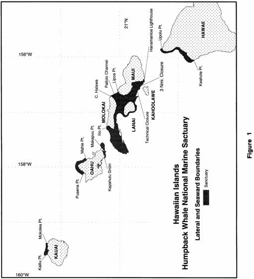
Appendix A to Subpart Q of Part 922 - Hawaiian Islands Humpback Whale, National Marine Sanctuary Boundary Description and Coordinates of the Lateral Boundary Closures and Excluded Areas.Appendix A provides a text and pictoral (see Figures 1-3) description of the Sanctuary boundary with specific lateral closure points and exclusion areas. The lateral extents (bounds) of each boundary area are closed by straight lines defined by at least two points. It may be necessary to extend these lines beyond the defining points to intersect the actual 100 fathom contour or the shoreline. Each point corresponds to a bounds number indicated in Figure 2. Digital files of the Sanctuary boundary (available in three common formats, ESRI Shape File, MapInfo Table, and an ASCII Exchange Format) are available from the Sanctuary office in Kihei, Maui, at the address listed above or by calling (808) 879-2818. These digital geographies are the best available representation of the verbal legal delineation and were derived from: the Hawaiian shoreline as supplied by State of Hawaii through the Office of Planning GIS Office, the NOAA and State of Hawaii agreed upon lateral boundary and exclusion areas, and the 100 fathom isobath digitized from the following 1:80,000 scale NOAA nautical charts-19327 - West Coast of Hawaii (9th ED, 4/29/89),
19347 - Channels between Molokai, Maui, Lanai, and Kahoolawe (17th ED, 12/13/97), 19351 - Channels between Oahu, Molokai, and Lanai (8th ED, 7/01/1989), 19357 - Island of Oahu (20th ED, 9/21/1996), and 19381 - Island of Kauai (8th ED, 7/17/1993)].For the portion of the Lanai region of the HIHWNMS west of Chart 19351,[157°42.8′ west] the 100 fathom contour was derived from the 1:250,000 chart 19340 - Hawaii to Oahu (24th ED, 1/09/1993).
All digital geography data have been referenced to WGS84 (NAD83) and have been converted to geographic (latitude and longitude) coordinates.
Sanctuary BoundaryA. As defined by the specific lateral boundaries in B, and except for excluded areas described in paragraph C of this section, the Hawaiian Islands Humpback Whale National Marine Sanctuary consists of the submerged lands and waters off the coast of the Hawaiian Islands seaward from the shoreline, cutting across the mouths of rivers and streams (see Figure 1):
1. To the 100-fathom (183 meter) isobath from Kailiu Point eastward to Mokolea Point, Kauai;
2. To the 100-fathom (183 meter) isobath from Puaena Point eastward to Mahie Point, and from the Kapahulu Groin in Waikiki eastward to Makapuu Point, Oahu;
3. To the 100-fathom (183 meter) isobath from Cape Halawa, Molokai, south and westward to Ilio Point, Molokai; southwestward to include Penguin Banks; eastward along the east side of Lanai; to the waters seaward of the three nautical mile limit north of Kahoolawe, to the Hanamanoia Lighthouse on Maui, and northward along the shoreline to Lipoa Point, Maui;
4. To the deep water area of Pailolo Channel from Cape Halawa, Molokai, to Lipoa Point, Maui, and southward;
5. To the 100-fathom (183 meter) isobath from Upolu Point southward to Keahole Point, Hawaii.
B. Lateral Closure Bounds for the Hawaiian Islands Humpback Whale National Marine Sanctuary Boundary (see Figure 2).

| Bound No. (Fig. 2) |
Geographic name | No. of points |
Latitude | Longitude |
|---|---|---|---|---|
| 1 | Kailiu Pt., Kauai | 2 | 22°13′24.7″ 22°16′33.5″ |
−159°34′52.2″ −159°35′59.4″ |
| 2 | Mokolea Pt., Kauai | 2 | 22°13′29.9″ 22°14′55.4″ |
−159°22′55.8″ -159°22′19.3″ |
| 3 | Puaena Pt., N. Oahu | 2 | 21°38′24.6″ 21°36′8.4″ |
−158°8′26.0″ −158°6′24.5″ |
| 4 | Mahie Pt., N. Oahu | 2 | 21°33′37.3″ 21°35′32.2″ |
−157°51′51.9″ −157°50′5.5″ |
| 5 | Kapahulu Groin, S. Oahu | 3 | 21°15′5.7″ 21°16′6.1″ 21°16′6.2″ |
−157°50′27.5″ −157°49′25.7″ −157°49′23.8″ |
| 6 | Makapuu Pt., S. Oahu | 2 | 21°18′39.6″ 21°19′44.7″ |
−157°38′56.7″ −157°35′46.1″ |
| 7 | Ilio Pt, Molokai | 2 | 21°13′25.7″ 21°13′27.0″ |
−157°18′45.8″ −157°15′14.4″ |
| 8 | Pailolo Channel, C. Halawa to Lipoa Pt. | 2 | 21°1′29.8″ 21°9′29.5″ |
−156°38′22.0″ −156°42′37.2″ |
| 9 | Hanamanoia Lighthouse, Maui | 2 | 20°34′21.8″ 20°34′58.4″ |
−156°26′51.1″ −156°24′45.2″ |
| 10 | 3 Nmi. closure around Kahoolawe | 51 | 20°35′58.1″ 20°35′59.9″ |
−156°29′32.0″ −156°29′33.0″ |
| 20°36′3.9″ | −156°29′35.5″ | |||
| 20°36′6.6″ | −156°29′36.9″ | |||
| 20°36′16.3″ | −156°29′43.1″ | |||
| 20°36′25.7″ | −156°29′49.9″ | |||
| 20°36′34.6″ | −156°29′57.3″ | |||
| 20°36′39.9″ | −156°30′2.2″ | |||
| 20°36′43.8″ | −156°30′5.5″ | |||
| 20°36′50.8″ | −156°30′12.1″ | |||
| 20°36′59.0″ | −156°30′16.5″ | |||
| 20°37′58.7″ | −156°30′22.7″ | |||
| 20°37′18.1″ | −156°30′29.5″ | |||
| 20°37′27.0″ | −156°30′36.8″ | |||
| 20°37′35.5″ | −156°30′44.8″ | |||
| 20°37′43.4″ | −156°30′53.4″ | |||
| 20°37′50.9″ | −156°31′2.4″ | |||
| 20°37′56.4″ | −156°31′10.0″ | |||
| 20°37′59.0″ | −156°31′13.2″ | |||
| 20°38′6.0″ | −156°31′22.7″ | |||
| 20°38′8.6″ | −156°31′26.8″ | |||
| 20°38′10.8″ | −156°31′29.9″ | |||
| 20°38′17.2″ | −156°31′39.9″ | |||
| 20°38′18.9″ | −156°31′43.0″ | |||
| 20°38′23.4″ | −156°31′48.4″ | |||
| 20°38′30.3″ | −156°31′58.0″ | |||
| 20°38′36.6″ | −156°32′7.9″ | |||
| 20°38′42.4″ | −156°32′18.3″ | |||
| 20°38′43.4″ | −156°32′20.5″ | |||
| 20°38′46.4″ | −156°32′25.9″ | |||
| 20°38′51.5″ | −156°32′36.7″ | |||
| 20°38′56.0″ | −156°32′47.7″ | |||
| 20°38′59.8″ | −156°32′59.1″ | |||
| 20°39′3.0″ | −156°33′10.7″ | |||
| 20°39′4.0″ | −156°33′15.7″ | |||
| 20°39′4.4″ | −156°33′17.0″ | |||
| 20°39′5.3″ | −156°33′21.1″ | |||
| 20°39′6.8″ | −156°33′28.7″ | |||
| 20°39′8.6″ | −156°33′40.7″ | |||
| 20°39′8.9″ | −156°33′44.4″ | |||
| 20°39′9.7″ | −156°33′49.6″ | |||
| 20°39′10.1″ | −156°33′53.8″ | |||
| 20°39′11.0″ | −156°34′0.3″ | |||
| 20°39′12.1″ | −156°34′12.4″ | |||
| 20°39′12.5″ | −156°34′24.4″ | |||
| 20°39′12.4″ | −156°34′25.4″ | |||
| 20°39′12.6″ | −156°34′30.5″ | |||
| 20°39′12.2″ | −156°34′42.6″ | |||
| 20°39′11.8″ | −156°34′47.7″ | |||
| 20°39′11.7″ | −156°34′48.9″ | |||
| 20°39′11.3″ | −156°34′55.8″ | |||
| 11 | Technical Cosure | 2 | 20°41′39.2″ 20°41′45.0″ |
−156°37′7.5″ −156°38′3.6″ |
| North of Kahoolawe | ||||
| 12 | Upolu Pt., Hawaii (Big Island) | 2 | 20°16′5.3″ 20°17′59.9″ |
−155°51′0.5″ −155°51′17.2″ |
| 13 | Keahole Pt., Hawaii (Big Island) | 2 | 19°43′39.6″ 19°43′41.5″ |
−156′3′42.7″ −156°4′14.5″ |
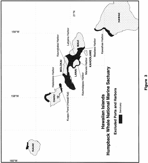
C. Excluded Ports and Harbors Bounds (see Figure 3).
| Bound No. (Fig.2) | Geographic Name | No. of Points | Latitude | Longitude |
|---|---|---|---|---|
| 14 | Kawaihae Harbor, Big Island exclusion | 2 | 20°2′14.3″ 20°2′25.3″ |
−155°50′2.5″ −155°49′57.7″ |
| 15 | Haleolono Harbor, Molokai exclusion | 2 | 21°5′3.5″ 21°5′4.8″ |
−157°14′58.6″ −157°14′55.2″ |
| 16 | Kaunakakai Harbor, Molokai exclusion | 4 | 21°5′13.9″ 21°4′49.2″ 21°4′38.5″ 21°5′7.4″ |
−157°1′35.7″ −157°1′58.3″ −157°1′41.2″ −157°1′15.0″ |
| 17 | Kaumalapau Harbor, Lanai exclusion | 2 | 20°47′9.2″ 20°47′1.1″ |
−156°59′32.2″ −156°59′31.3″ |
| 18 | Manele Harbor, Lanai exclusion | 2 | 20°44′33.2″ 20°44′35.2″ |
−156°53′12.9″ −156°53′14.1″ |
| 19 | Lahaina Harbor, Maui exclusion | 2 | 20°52′18.3″ 20°52′18.8″ |
−156°40′45.0″ −156°40′44.0″ |
| 20 | Maalaea Harbor, Maui exclusion | 2 | 20°47′32.1″ 20°47′24.8″ |
−156°30′35.0″ −156°30′39.6″ |
| 21 | Western closure Kuapa Pond (Hawaii Kai), Oahu | 2 | 21°17′7.0″ 21°17′6.5″ |
−157°43′7.7″ −157°43′7.0″ |
| 22 | Eastern closure Kuapa Pond (Hawaii Kai), Oahu | 2 | 21°16′53.3″ 21°16′51.9″ |
−157°42′42.7″ −157°42′40.3″ |
Appendix A to Subpart R of Part 922 - Thunder Bay National Marine Sanctuary and Underwater Preserve Boundary Coordinates
15:3.1.2.2.13.18.17.10.38 : Appendix A
Appendix A to Subpart R of Part 922 - Thunder Bay National Marine Sanctuary and Underwater Preserve Boundary Coordinates[Based on North American Datum of 1983]
| Point ID | Latitude (north) | Longitude (west) |
|---|---|---|
| 1 | 44.512834 | −82.329519 |
| 2 | 44.858147 | −82.408717 |
| 3 | 45.208484 | −82.490596 |
| 4 | 45.335902 | −82.52064 |
| 5 | 45.771937 | −83.483974 |
| 6 | 45.773944 | −83.636867 |
| 7 | 45.833333 | −83.586892 |
| 8 | 45.833333 | −84.333333 |
| 9 * | 45.662858 | −84.333333 |
| 10* | 45.41733 | −83.77327 |
| 11 | 45.42103 | −83.79487 |
| 12 | 45.42708 | −83.79371 |
| 13 | 45.42343 | −83.75318 |
| 14 | 45.41748 | −83.75333 |
| 15 | 45.41210 | −83.76805 |
| 16 * | 45.40738 | −83.76785 |
| 17 * | 45.29672 | −83.41908 |
| 18 | 45.29682 | −83.40965 |
| 19 | 45.29010 | −83.40965 |
| 20 | 45.29464 | −83.41914 |
| 21 * | 45.29681 | −83.42277 |
| 22 * | 45.06632 | −83.40715 |
| 23 * | 45.06560 | −83.40810 |
| 24 * | 44.511734 | −83.320169 |
| 25 | 44.512834 | −82.329519 |
The coordinates in the table above marked with an asterisk (*) are not part of the sanctuary boundary. These coordinates are landward reference points used to draw a line segment that intersects with the shoreline for the purpose of charting the boundary.
[79 FR 52972, Sept. 5, 2014; 80 FR 12080, Mar. 6, 2015, as amended at 80 FR 79684, Dec. 23, 2015]Appendix A to Subpart S of Part 922 - Mallows Bay-Potomac River Marine Sanctuary Boundary Description and Coordinates of the Lateral Boundary Closures and Excluded Areas
15:3.1.2.2.13.19.17.8.40 : Appendix A
Appendix A to Subpart S of Part 922 - Mallows Bay-Potomac River Marine Sanctuary Boundary Description and Coordinates of the Lateral Boundary Closures and Excluded AreasCoordinates listed in this appendix are unprojected (Geographic) and based on the North American Datum of 1983.
Table 1 - Coordinates for Sanctuary
| Point ID | Latitude | Longitude |
|---|---|---|
| 1 | 38.39731 | −77.31008 |
| 2 | 38.39823 | −77.31030 |
| 3 | 38.39856 | −77.31059 |
| 4 | 38.39886 | −77.31074 |
| 5 | 38.39917 | −77.31067 |
| 6 | 38.40014 | −77.31074 |
| 7 | 38.40090 | −77.31145 |
| 8 | 38.40138 | −77.31215 |
| 9 | 38.40197 | −77.31236 |
| 10 | 38.40314 | −77.31278 |
| 11 | 38.40658 | −77.31377 |
| 12 | 38.40984 | −77.31465 |
| 13 | 38.41388 | −77.31692 |
| 14 | 38.41831 | −77.31913 |
| 15 | 38.41974 | −77.31930 |
| 16 | 38.42352 | −77.31971 |
| 17 | 38.42548 | −77.32030 |
| 18 | 38.42737 | −77.32081 |
| 19 | 38.43091 | −77.32240 |
| 20 | 38.43163 | −77.32242 |
| 21 | 38.43350 | −77.32263 |
| 22 | 38.43384 | −77.32269 |
| 23 | 38.43430 | −77.32265 |
| 24 | 38.43461 | −77.32229 |
| 25 | 38.43498 | −77.32146 |
| 26 | 38.43526 | −77.32057 |
| 27 | 38.43522 | −77.32040 |
| 28 | 38.47321 | −77.31845 |
| 29 | 38.47434 | −77.31874 |
| 30 | 38.47560 | −77.31752 |
| 31 | 38.47655 | −77.31686 |
| 32 | 38.47748 | −77.31666 |
| 33 | 38.47821 | −77.31604 |
| 34 | 38.47871 | −77.31554 |
| 35 | 38.47885 | −77.31563 |
| 36 | 38.47905 | −77.31559 |
| 37 | 38.47921 | −77.31578 |
| 38 | 38.47943 | −77.31592 |
| 39 | 38.47985 | −77.31592 |
| 40 | 38.48493 | −77.31335 |
| 41 * | 38.48554 | −77.27298 |
| 42 * | 38.39793 | −77.25704 |
| 43 | 38.39731 | −77.31008 |
The coordinates in the table above marked with an asterisk (*) are not a part of the sanctuary boundary. These coordinates are landward reference points used to draw a line segment that intersects with the shoreline.